| Разработчик: | HydroloGIS S.r.l. (4) | ||
| Цена: | Бесплатно | ||
| Рейтинги: | 0 | ||
| Отзывы: | 0 Написать отзыв | ||
| Списки: | 0 + 0 | ||
| Очки: | 0 + 1 (5.0) ¡ | ||
| App Store | |||
Описание
")
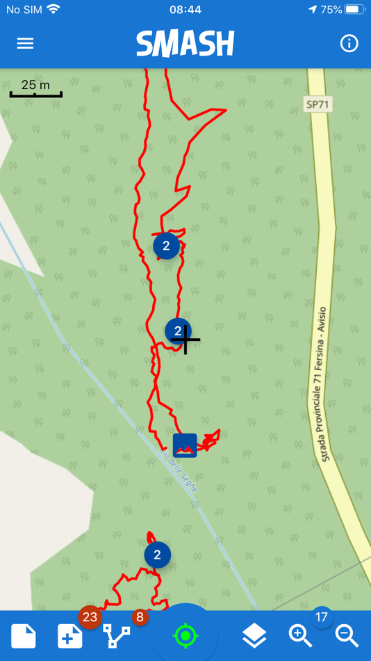
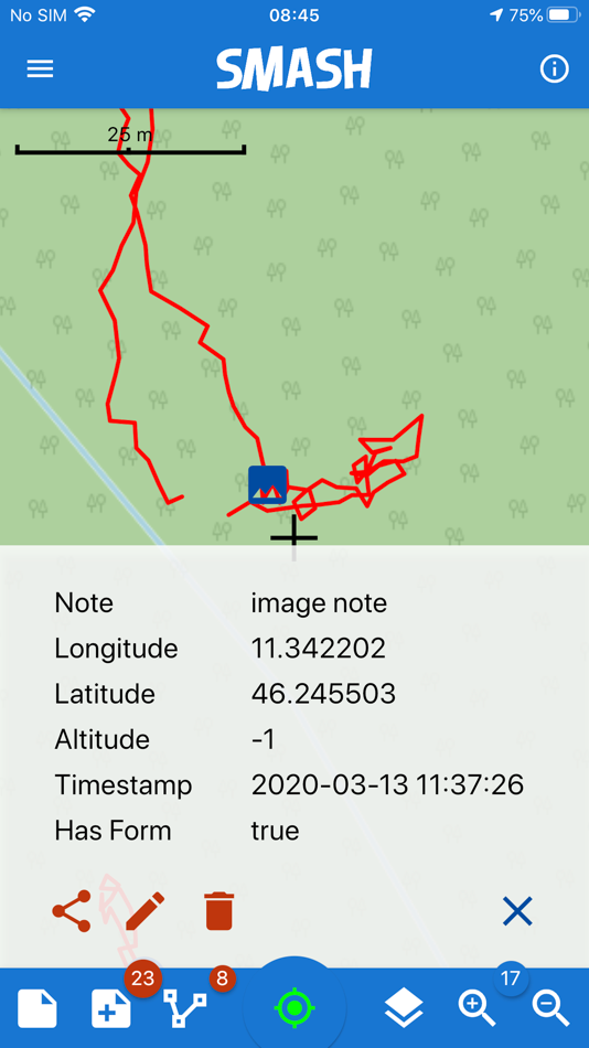
The main aim of SMASH is to have a tool that:
* fits in any pocket and can be always at hand, when needed
* gives the possibility to take geo-referenced and possibly orientated pictures during a survey, with further possibility to import them into GIS applications like gvSIG
* is able to easily exploit an Internet connection, if available
* is extremely easy to use and intuitive, providing just few important functions
The main features available in SMASH are:
* geo-referenced notes
* geo-referenced and oriented pictures
* gps track logging
* form-based data surveys
* easy export of collected data
* a map view for navigation with support for raster tiles and gpx vector data
* geopackage (OGC standard) support
Скриншоты


Что нового
- Версия: 1.10.3
- Обновлено:
- * postgis connection enhancements
* new form widgets (tap counter, wheel, autocomplete combo with urls)
* memory enabled forms
* bugfixes
Цена
- Сегодня: Бесплатно
- Минимум: Бесплатно
- Максимум: Бесплатно
Отслеживайте цены
Разработчик
- HydroloGIS S.r.l.
- Платформы: Android Приложения (2) iOS Приложения (2)
- Списки: 0 + 0
- Очки: 0 + 1 ¡
- Рейтинги: 0
- Отзывы: 0
- Скидки: 0
- Видео: 1
- RSS: Подписаться
Очки
0 ☹️
Рейтинги
0 ☹️
Списки
0 ☹️
Отзывы
Ваш отзыв будет первым 🌟
Дополнительная информация
- Версия: 1.10.3
- ID: eu.hydrologis.smash
- Категория:
iOS Приложения›Производительность - Операционные системы:
iPad,iPhone,iOS 12.0 и выше - Размер:
63 Mb - Поддерживаемые языки:
English - Возрастные ограничения:
4+ - App Store Рейтинг:
5.0(1) - Обновлено:
- Дата выпуска:
Контакты
Вам также могут понравиться
-
- Field Control
- iOS Приложения: Производительность От: Field Control
- Бесплатно
- Списки: 0 + 0 Рейтинги: 0 Отзывы: 0
- Очки: 0 + 2 (5.0) Версия: 15.8.11 Field Control is a platform for companies that have professionals in the field that increases control, organization and improves the relationship with customers in a practical and ... ⥯
-
- Digital Pigeon
- iOS Приложения: Производительность От: Digital Pigeon
- Бесплатно
- Списки: 0 + 0 Рейтинги: 0 Отзывы: 0
- Очки: 0 + 2 (4.0) Версия: 2.4.7 Digital Pigeon is a companion app to the Digital Pigeon desktop and web apps . It allows you to monitor upload progress, track and manage your big Digital Pigeon files easily, without ... ⥯
-
- Digital Welcome Pack
- iOS Приложения: Производительность От: Digital Welcome Pack SL
- Бесплатно
- Списки: 0 + 0 Рейтинги: 0 Отзывы: 0
- Очки: 0 + 0 Версия: 1.3.6 Digital Welcome Pack is an innovative application designed to revolutionise the way visitors are welcomed and resources are shared in the audiovisual industry. With this app, ... ⥯
-
- Digital Notes: Note Taking App
- iOS Приложения: Производительность От: Digital Hole Pvt. Ltd.
- $1.99
- Списки: 3 + 3 Рейтинги: 0 Отзывы: 0
- Очки: 17 + 83 (4.7) Версия: 2.2 Use the Apple Pencil or your finger to doodle, sketch ideas, or jot down a handwritten note in Digital Notes. User data is stored on iCloud, so your notes will be protected & synced on ⥯
-
- Digital Sea Service
- iOS Приложения: Производительность От: Digital Sea Service
- Бесплатно
- Списки: 0 + 0 Рейтинги: 0 Отзывы: 0
- Очки: 0 + 0 Версия: 1.9 Collaborate effortlessly with your crew to track your sea service. Whether you re a deckhand logging your own hours or a captain managing a crew of 50, we ve got you covered. ... ⥯
-
- Digital Samba
- iOS Приложения: Производительность От: Digital Samba, SL
- Бесплатно
- Списки: 0 + 0 Рейтинги: 0 Отзывы: 0
- Очки: 0 + 0 Версия: 1.35.0 With Digital Samba you can join meetings, online events, and webinars on the go. It's easy to use while offering a delightful, feature-rich experience. -- Features: Enjoy crystal-clear ⥯
-
- Digital Desk AISM
- iOS Приложения: Производительность От: Allied Digital Services LLC
- Бесплатно
- Списки: 0 + 0 Рейтинги: 0 Отзывы: 0
- Очки: 0 + 1 (5.0) Версия: 2.0.37 Digital Desk (formally ADiTaaS) is intuitive enterprise service management for the performance of the digital enterprise, on-premises or in the cloud. It provides end-to-end visibility ⥯
-
- Fieldproxy: Field Operations
- iOS Приложения: Производительность От: Field Proxy
- Бесплатно
- Списки: 0 + 0 Рейтинги: 0 Отзывы: 0
- Очки: 0 + 0 Версия: 1.0.71 Fieldproxy helps managers and teams from retail, restaurant chains, consumer goods, construction, and real estate organizations to collect data from the field in a structured format. ... ⥯
-
- Spiral by Digital Generalists
- iOS Приложения: Производительность От: Digital Generalists, LLC.
- $0.99
- Списки: 0 + 0 Рейтинги: 0 Отзывы: 0
- Очки: 0 + 8 (4.9) Версия: 1.0.5 Spiral - The Ultimate Pocket Notepad Spiral is the perfect application for lovers of pocket-sized paper notepads who want to take quick notes, draw, sketch, doodle, and more! All these ⥯
-
- Digital Tattoo Forms
- iOS Приложения: Производительность От: David Richman
- * Бесплатно
- Списки: 0 + 0 Рейтинги: 0 Отзывы: 0
- Очки: 0 + 2 (5.0) Версия: 1.3.2 Digital Tattoo Forms is a tattoo and piercing release form App that Artists and clients fill out before the procedure starts.. You can access clients and artists in real time. If you ... ⥯
-
- Field - Touch
- iOS Приложения: Производительность От: Dassault Aviation
- Бесплатно
- Списки: 0 + 0 Рейтинги: 0 Отзывы: 0
- Очки: 1 + 0 Версия: 4.7.3 FIELD6 is the solution developed by Dassault Aviation that will allow users to: navigate through the last updated version of the maintenance documentation set, Basic & Supplemental ... ⥯
-
- Digital Irrigation
- iOS Приложения: Производительность От: Eurosystem2000
- Бесплатно
- Списки: 0 + 0 Рейтинги: 0 Отзывы: 0
- Очки: 0 + 0 Версия: 1.5.1 The DIGITAL IRRIGATION platform guarantees timely and optimised irrigation management, in which the user is able to manage all his irrigation machines with absolute precision in ... ⥯
-
- Digital Invitation Card Makers
- iOS Приложения: Производительность От: Ankitbhai Jivani
- Бесплатно
- Списки: 0 + 0 Рейтинги: 0 Отзывы: 0
- Очки: 0 + 0 Версия: 1.1 Invitation Card Maker is your online solution for every event. You ll find an overflowing gallery of options in assorted styles and designs, and our templates will guide you through ... ⥯
-
- Field Service Assistant
- iOS Приложения: Производительность От: Sarka Tyri Software LLC
- Бесплатно
- Списки: 0 + 0 Рейтинги: 0 Отзывы: 0
- Очки: 0 + 6,338 (4.7) Версия: 5.1.7 Field Service Assistant is a contact management program for Jehovah's Witnesses. It manages calls, placements, and calculates volunteered time. Features Include: Start/Stop timer. Sort ⥯