| Developer: | ESRI (59) | ||
| Price: | Free | ||
| Rankings: | 0 | ||
| Reviews: | 0 Write a Review | ||
| Lists: | 0 + 0 | ||
| Points: | 0 + 35 (4.3) ¡ | ||
| App Store | |||
Description
")
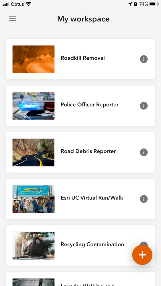
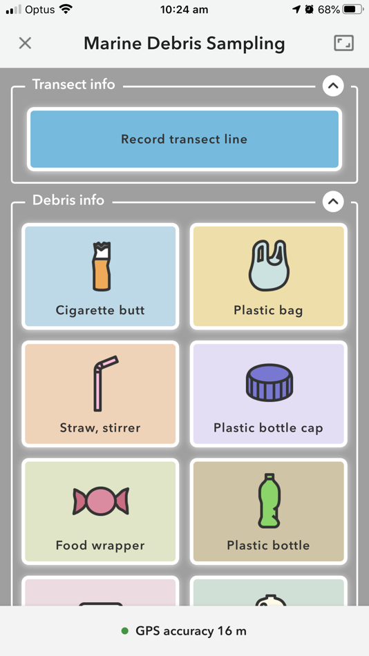
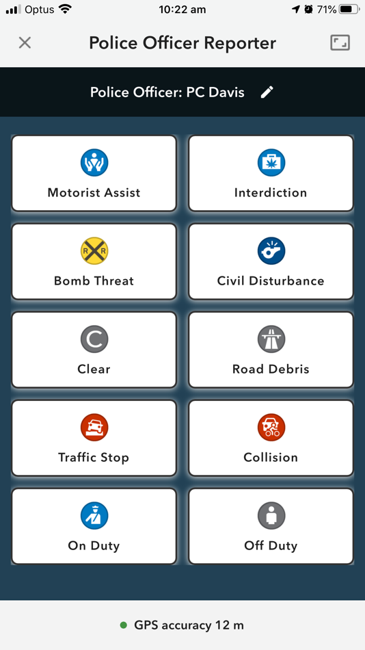
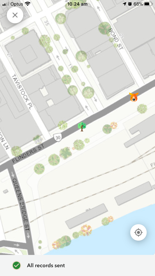
Screenshots


What's new
- Version: 1.24.3
- Updated:
- - On iPhone 17 Pro and iPhone 17 Pro Max with iOS 26 or later, a bug was fixed in which the app would crash when taking a photo.
- A bug was fixed in which project updates were not shown in the mobile app.
- A bug was fixed in which the value from the sort field was submitted instead of the value field, when using a dynamic choice list.
Price History
- Today: Free
- Minimum: Free
- Maximum: Free
Track prices
Developer
- ESRI
- Platforms: Android Apps (27) iOS Apps (31) macOS Apps (1)
- Lists: 0 + 0
- Points: 1 + 8,769 ¡
- Rankings: 0
- Reviews: 0
- Discounts: 0
- Videos: 2
- RSS: Subscribe
Points
0 ☹️
Rankings
0 ☹️
Lists
0 ☹️
Reviews
Be the first to review 🌟
Additional Information
- Version: 1.24.3
- Category:
iOS Apps›Utilities - OS:
iPad,iPhone,iOS 13.0 and up - Size:
161 Mb - Supported Languages:
Arabic,Bosnian,Bulgarian,Catalan,Chinese,Croatian,Czech,Danish,Dutch,English,Estonian,Finnish,French,German,Greek,Hebrew,Hungarian,Indonesian,Italian,Japanese,Korean,Latvian,Lithuanian,Norwegian,Polish,Portuguese,Romanian,Russian,Serbian,Slovak,Slovenian,Spanish,Swedish,Thai,Turkish,Ukrainian,Vietnamese - Content Rating:
4+ - App Store Rating:
4.3(35) - Updated:
- Release Date:
Contacts
«ArcGIS QuickCapture» is a Utilities app for iOS, developed by «ESRI». It was first released on and last updated on . This app is currently free. This app has not yet received any ratings or reviews on AppAgg. On App Store, the current store rating is 4.3 based on 35 votes. Available languages: Arabic, Bosnian, Bulgarian, Catalan, Chinese, Croatian, Czech, Danish, Dutch, English, Estonian, Finnish, French, German, Greek, Hebrew, Hungarian, Indonesian, Italian, Japanese, Korean, Latvian, Lithuanian, Norwegian, Polish, Portuguese, Romanian, Russian, Serbian, Slovak, Slovenian, Spanish, Swedish, Thai, Turkish, Ukrainian, Vietnamese. AppAgg continuously tracks the price history, ratings, and user feedback for «ArcGIS QuickCapture». Subscribe to this app or follow its RSS feed to get notified about future discounts or updates.
- 🌟 Share
- App Store
You may also like
-
- ArcGIS AppStudio Player
- iOS Apps: Utilities By: ESRI
- Free
- Lists: 0 + 0 Rankings: 0 Reviews: 0
- Points: 0 + 12 (4.2) Version: 5.5.23 AppStudio Player lets you instantly view mapping applications created with ArcGIS AppStudio. It offers you a great way to quickly test your own creations before you build and ... ⥯
-
- Measure Map Pro
- iOS Apps: Utilities By: Blue Blink One, SL
- Free
- Lists: 2 + 2 Rankings: 0 Reviews: 0
- Points: 4 + 791 (4.6) Version: 13.10.3 Measure Map Pro lets you quickly and easily measure multiple distances, perimeters and areas with laser sharp precision!. Use it for small areas or large, then share with coworkers. ... ⥯
-
- InfraMarker RFID
- iOS Apps: Utilities By: Berntsen International, Inc.
- Free
- Lists: 0 + 0 Rankings: 0 Reviews: 0
- Points: 0 + 0 Version: 2.8.3 InfraMarker RFID app, compatible UHF and NFC RFID tags, readers, and host applications, such as ArcGIS Field Maps and ArcGIS Survey123 applications work together to transform the way ... ⥯
-
- TicketAccess
- iOS Apps: Utilities By: PelicanCorp
- Free
- Lists: 0 + 0 Rankings: 0 Reviews: 0
- Points: 0 + 0 Version: 1.2 TicketAccess is a comprehensive ticket management platform designed specifically for "call before you dig" operations and damage prevention. It enables users to efficiently handle ... ⥯
-
- SCATalogue
- iOS Apps: Utilities By: California Department of Fish and Wildlife
- Free
- Lists: 0 + 0 Rankings: 0 Reviews: 0
- Points: 0 + 3 (5.0) Version: 1.85 The SCATalogue app is a creation of the California Department of Fish and Wildlife, Office of Spill Prevention and Response (CDFW, OSPR). SCATalogue simplifies the collection of ... ⥯
-
- Socode - Source Code Viewer
- iOS Apps: Utilities By: Huizhou Jiqu Technology Co., Ltd.
- $4.99
- Lists: 0 + 0 Rankings: 0 Reviews: 0
- Points: 0 + 15 (4.4) Version: 1.8.3 # What is Socode? Socode is a source code reader designed for iPhone, iPad devices. You can view the source code on your mobile device anytime, anywhere. # Features - Syntax ... ⥯
-
- GasSCAN
- iOS Apps: Utilities By: Magnolia River
- Free
- Lists: 0 + 0 Rankings: 0 Reviews: 0
- Points: 0 + 7 (5.0) Version: 2.0.0 An application to allow the scanning of a barcode or QR code that meets ASTM F2897 standard. Application stores all scans and includes GPS data while scanning. Once a list of scans has ⥯
-
- Classic FieldSeeker Mosquito
- iOS Apps: Utilities By: Frontier Precision, Inc.
- Free
- Lists: 0 + 0 Rankings: 0 Reviews: 0
- Points: 0 + 19 (3.0) Version: 1.0.250715 The FieldSeeker GIS for Mosquito Control cross-platform mobile app (CPMA) is an easy and convenient way for mosquito and vector control operations to record and view field activities ... ⥯
-
- LaunchPoint SiteRight
- iOS Apps: Utilities By: LaunchPoint Software Systems Inc.
- Free
- Lists: 0 + 0 Rankings: 0 Reviews: 0
- Points: 0 + 10 (3.8) Version: 1.2.281 SiteRight collects precise GIS field data using customized Forms, project specific Data Dictionaries and map-based data capture tools Data is safely stored in the cloud for later use ... ⥯
-
- SpotOnResponse
- iOS Apps: Utilities By: SpotOnResponse
- Free
- Lists: 0 + 0 Rankings: 0 Reviews: 0
- Points: 0 + 1 (5.0) Version: 5.0.0 SpotOnResponse is available on your desktop in a browser for use in operations centers and now on your iPhone or iPad for mobile use. The SpotOnResponse iOS application is a complement ⥯
-
- 3D地球-satellite and 3D terrain
- iOS Apps: Utilities By: 家会 黎
- Free
- Lists: 0 + 0 Rankings: 0 Reviews: 0
- Points: 0 + 3 (3.7) Version: 2.7 3D Earth is a global satellite mapping software that integrates terrain, contour lines, geographic measurements, markers, altitude, compass, and more. Here, you can view real-time ... ⥯
-
- UTTO vLocate® Mapper
- iOS Apps: Utilities By: IPEG Corporation
- Free
- Lists: 0 + 0 Rankings: 0 Reviews: 0
- Points: 0 + 2 (5.0) Version: 0.1.25 UTTO vLocate® Mapper enables field tech map & relocate of buried assets and facilities with simple, fast centimeter accuracy. Patented (№ 16880702) and designed specifically for the ... ⥯