| Kehittäjä: | Rubber Authority of Thailand (4) | ||
| Hinta: | Ilmainen | ||
| Rankingissa: | 0 | ||
| Arvostelut: | 0 Kirjoita arvostelu | ||
| Listat: | 0 + 0 | ||
| Pisteet: | 1 + 0 ¡ | ||
| App Store | |||
Kuvaus
")
โดยมีฟังก์ชันดังนี้
- การลงทะเบียนเข้างานแอปพลิเคชัน
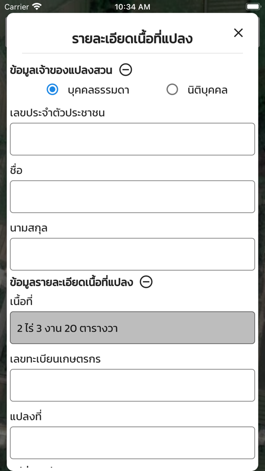
- การแสดงรายละเอียดแปลงสวนยางพาราของเกษตรกร
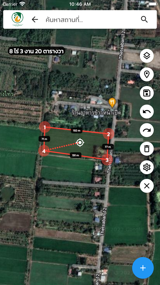
- การวาดและจัดการแปลงสวนยางพาราของเกษตรกร
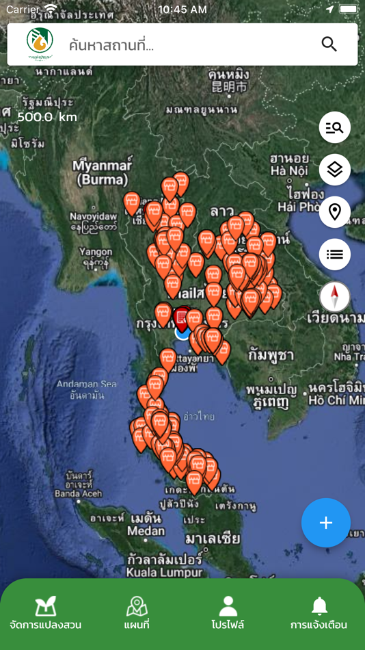
- การแสดงที่ตั้งแปลงสวนยางพารา และพิกัดที่ตั้งประเภทต่าง ๆ ของ กยท.
- การแจ้งเตือน
Näyttökuvat
Hinta
- Tänään: Ilmainen
- Vähintään: Ilmainen
- Enintään: Ilmainen
Seuraa hintoja
Kehittäjä
- Rubber Authority of Thailand
- Alustat: Android Sovellukset (2) iOS Sovellukset (2)
- Listat: 0 + 0
- Pisteet: 1 + 0 ¡
- Rankingissa: 0
- Arvostelut: 0
- Alennukset: 0
- Videot: 0
- RSS: Tilaa
Pisteet
-
")
- 13 Umar Jutt (Jutt)
- +1
")
Rankingissa
0 ☹️
Listat
0 ☹️
Arvostelut
Ole ensimmäinen tarkistaa 🌟
Lisätietoja
- Versio: 1.3.2
- ID: th.co.raot.gis
- Luokka:
iOS Sovellukset›Apuohjelmia - Käyttöjärjestelmä:
iPad,iPhone,iOS 14.0 tai uudempi - Koko:
71 Mb - Tuettu kieli:
English - Sisällön ikärajoitus:
4+ - App Store Luokitus:
0 - Päivitetty:
- Julkaisupäivämäärä:
Yhteystiedot
- Verkkosivusto:
 http://www.raot.co.th/
Saatat myös pitää
-
- GIS CATG
- iOS Sovellukset: Apuohjelmia Tekijänä: Vietnam Posts and Telecommunications Group
- Ilmainen
- Listat: 0 + 0 Rankingissa: 0 Arvostelut: 0
- Pisteet: 0 + 0 Versio: 1.1.7 Ứng dụng GIS CATG hỗ trợ tra cứu thông tin các đối tượng như nguồn nước trụ cứu hỏa, công trình nguy cơ cháy nổ, tòa nhà cao tầng,... ⥯
-
- GIS Camera Reporter
- iOS Sovellukset: Apuohjelmia Tekijänä: Metropolitan Waterworks Authority
- Ilmainen
- Listat: 1 + 0 Rankingissa: 0 Arvostelut: 0
- Pisteet: 0 + 1 (5.0) Versio: 7.1.7 GIS camera reporter เป็นแอพพลิเคชั่นที่ใช้ในการส่งพิกัด พร้อมรูปถ่าย และข้อความ บนแผนที่ GIS ที่ใช้งานด้านวิศวกรรมและบริการ ของการประปานครหลวง เช่น งานแจ้งตำแหน่งท่อแตกรั่ว ... ⥯
-
- Foto-GIS
- iOS Sovellukset: Apuohjelmia Tekijänä: NGN IT-Solutions GmbH
- Ilmainen
- Listat: 0 + 0 Rankingissa: 0 Arvostelut: 0
- Pisteet: 0 + 0 Versio: 2.41 Foto-GIS application allows you to conveniently and professionally automate your construction site foto documentation. Save up to 80% of your time and energy. Images are automatically ... ⥯
-
- GMapper GIS GPS & Area Measure
- iOS Sovellukset: Apuohjelmia Tekijänä: Suphawadee Yaprasat
- * Ilmainen
- Listat: 0 + 0 Rankingissa: 0 Arvostelut: 0
- Pisteet: 0 + 5 (4.4) Versio: 1.13.3 Explore and Manage Maps with Precision with GMapper Gis Mapper Surveys Experience unparalleled accuracy in land surveying and management with GMapper Gis Mapper Surveys! Designed for ... ⥯
-
- GNIDA GIS
- iOS Sovellukset: Apuohjelmia Tekijänä: NIC
- Ilmainen
- Listat: 0 + 0 Rankingissa: 0 Arvostelut: 0
- Pisteet: 0 + 0 Versio: 1.0 Citizen Centric One Map Greater Noida Mobile GIS App to get Information of Plots & Nearby Facilities based on User's Location. Geo-Spatial Technology & Services Division, NIC has ... ⥯
-
- עיריית ירושלים GIS
- iOS Sovellukset: Apuohjelmia Tekijänä: Municipality of Jerusalem
- Ilmainen
- Listat: 0 + 0 Rankingissa: 0 Arvostelut: 0
- Pisteet: 0 + 0 Versio: 1.1 מערכת מיפוי GIS של עיריית ירושלים ⥯
-
- My GIS Agent
- iOS Sovellukset: Apuohjelmia Tekijänä: GLOBAL INSURANCE SERVICE INC
- Ilmainen
- Listat: 0 + 0 Rankingissa: 0 Arvostelut: 0
- Pisteet: 0 + 0 Versio: 1.0.22 The My GIS Agent app helps Global Insurance Services, Inc customers stay in touch with their GIS agent from anywhere they are. Ever wondered how much you need to pay upon renewal? Or ... ⥯
-
- GeoSearch Thailand
- iOS Sovellukset: Apuohjelmia Tekijänä: GIS Co., Ltd.
- Ilmainen
- Listat: 0 + 0 Rankingissa: 0 Arvostelut: 0
- Pisteet: 0 + 0 Versio: 1.6.0 Our Geosearch API helps turn your addresses in Thailand into geographic coordinates, find POIs or the other way round. Run batch queries, store the results, and display them on a map ... ⥯
-
- Pro Vision AR
- iOS Sovellukset: Apuohjelmia Tekijänä: Virtual GIS LLC
- Ilmainen
- Listat: 0 + 0 Rankingissa: 0 Arvostelut: 0
- Pisteet: 0 + 4 (5.0) Versio: 1.53 ProVision AR allows users to experience a real-world display of geographically referenced 3D data on their iOS device. Data are projected onto the real world in augmented reality ... ⥯
-
- VECMAP
- iOS Sovellukset: Apuohjelmia Tekijänä: Avia-GIS
- Ilmainen
- Listat: 0 + 0 Rankingissa: 0 Arvostelut: 0
- Pisteet: 0 + 0 Versio: 3.2.2 The VECMAP® mobile app is a complimentary app only for users granted access via the VECMAP® software package. This app is used for field data entry into your VECMAP® data collection ... ⥯
-
- GTRPlus
- iOS Sovellukset: Apuohjelmia Tekijänä: SIGIS Soluciones Integrales GIS, C.A.
- Ilmainen
- Listat: 0 + 0 Rankingissa: 0 Arvostelut: 0
- Pisteet: 0 + 1 (5.0) Versio: 1.82.0 GTRPlus ® is a tracking system that allows continuous monitoring and immediate location of private vehicles. It provides several tools related to the safe operation of the car; cruise ... ⥯
-
- VerdeComo
- iOS Sovellukset: Apuohjelmia Tekijänä: R3 GIS Srl
- Ilmainen
- Listat: 0 + 0 Rankingissa: 0 Arvostelut: 0
- Pisteet: 0 + 0 Versio: 1.3.4 La presente applicazione consente ai Cittadini di Como di segnalare eventuali necessità manutentive nelle aree verdi pubbliche in manutenzione all'Ufficio Parchi e Giardini ... ⥯
-
- Ruty
- iOS Sovellukset: Apuohjelmia Tekijänä: América Gis
- Ilmainen
- Listat: 0 + 0 Rankingissa: 0 Arvostelut: 0
- Pisteet: 0 + 0 Versio: 1.0.1 Ruty - Seguimiento y monitoreo vehicular ⥯
-
- GEM - PRADAN
- iOS Sovellukset: Apuohjelmia Tekijänä: Laxmiprasad Putta
- Ilmainen
- Listat: 0 + 0 Rankingissa: 0 Arvostelut: 0
- Pisteet: 0 + 0 Versio: 1.2.2 GIS Engagement in MGNREGS (GEM) application provides an interface to collect data for all watershed development components. The mobile application also captures geo tagged images in ... ⥯