| Vývojář: | Harald Meyer (49) | ||
| Cena: | * Zdarma | ||
| Hodnocení: | 0 | ||
| Recenze: | 0 Napsat recenzi | ||
| Seznamy: | 0 + 0 | ||
| Body: | 1 + 3 (4.3) ¡ | ||
| Mac App Store | |||
Popis
")
Please contact us if you have any questions, problems, or feature requests: https://www.cartograph.eu/v3/contact/
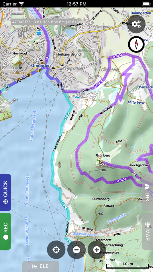
## Map features
- View Mapsforge offline vector maps (including OpenAndroMaps.org maps!).
- Support for OpenAndroMaps render themes (Elevate, Elements), which are great for hiking, mountainbiking, running, and other outdoor activities.
- Other supported offline map formats: MBTiles (raster and OpenMapTiles MVT vector), TwoWays RMAP, Locus SQLite, Oruxmaps SQLite, Garmin IMG (non-NT).
- Supported online map types: Mapbox vector tiles (MVT - OpenMapTiles style), Bing quadkey tile format (raster), OpenStreetMap slippy tile format (raster), raster WMS (web map service, including layers and styles), MapLibre.
- Offline hillshading and slope mapping (*).
- Mapsforge multi-maps (combine multiple Mapsforge maps into a single map) (*).
- Classic Mapsforge and new Mapsforge VTM rendering support.
- Stack multiple map layers on top of each other (including transparency) (*).
- 3D buildings (*).
- Create custom Mapsforge maps (**).
- Grid overlays, including WGS84, UTM, MGRS (military grid reference system), and many local projections (*).
- Supports classical latitude/longitude (WGS84), UTM, MGRS, and many local (proj4) coordinate display projections.
- Online map tile downloader (*) (see https://www.cartograph.eu/v3/online-map-tile-downloader/).
- Image to map calibration tool (*) (https://www.cartograph.eu/v3/image-to-map-calibration-tool/).
- Zoom lock.
## Tracks and routing
- Track recording while the app is in background (*).
- Draw custom tracks using the track drawing tool (*).
- Photo-, video-, and audio waypoints (*).
- BRouter offline route calculation (*).
- OSRM routing.
- Google Directions, Bing Routes (**).
- Basic offline navigation with voice instructions and custom audio instructions (*).
- Waypoint alerts (*).
- Current route elevation profile (*).
- Import and export *.gpx, *.kml, *.kmz (only import) tracks.
- Import EXIF JPEG photos and Google Takeout as bookmarks (*).
- Garmin icon support (*).
- Live friend tracking (share your location with friends live on a map) (*).
## Other features
- Measurement tools (distance, elevation profile, circular distance) (*).
- Workspaces (manage sets of maps/overlays/tracks) (*).
- Cloud sync (backup data and synchronize data among multiple devices) using Microsoft OneDrive, DropBox, or your own web server (*).
- "What's here" (reverse geo-code).
- Built-in offline overlays for drinking water, supermarkets, hostels, and restaurants.
- Search: Google Places, Bing, Nominatim (**).
- Supports WunderLINQ and Carpe-Iter-Control.
- Included translations: Czech, English, French, German, Hungarian, Italian, Polish, Traditional Chinese.
- Create your own translations: https://www.cartograph.eu/v3/add-ons/translations/
- Bluetooth heart rate, cadence, and speed sensors.
Items marked with (*) are available in the full version which is available as an in-app-purchase.
Items marked with (**) require credits which can be obtained in the app.
## In app purchases
The Cartograph app offers in-app-purchases for activating all features, and for accessing 3rd party services (such as Google Directions).
A detailed description of all products and the Terms of Use are available here: https://www.cartograph.eu/v3/in-app-purchase-info/
## Disclaimer
The Cartograph app allows you to record your location ("track recording") while the app is in background. Location services can significantly increase battery usage.
Snímky obrazovky


Novinky
- Verze: 3.8.7
- Aktualizováno:
- 3.8.7 (19-11-2025)
- Added: Croation translation (thanks to Ana and Goran).
- Fixed: Altitude gain and minimum GPS distance bug in sensor manager.
Cena
-
* Nákupy v aplikaci - Dnes: Zdarma
- Minimální: Zdarma
- Maximální: Zdarma
Sledovat ceny
Vývojář
- Harald Meyer
- Platformy: iOS Aplikace (25) macOS Aplikace (24)
- Seznamy: 1 + 2
- Body: 7 + 1,111 ¡
- Hodnocení: 0
- Recenze: 0
- Slevy: 0
- Videa: 24
- RSS: Odebírat
Body
-

- 125 d7om aisubiai
- +1

Hodnocení
0 ☹️
Seznamy
0 ☹️
Recenze
Buďte první, kdo bude hodnotit 🌟
Další informace
Kontakty
- 🌟 Sdílet
- Mac App Store
Mohlo by se Vám také líbit
-
- Maps for OSM
- macOS Aplikace: Navigace Podle: Michael Roennau
- Zdarma
- Seznamy: 0 + 0 Hodnocení: 0 Recenze: 0
- Body: 2 + 1 (5.0) Verze: 4.9 View maps from OpenStreetMap (app is not affiliated with OSM organization). Choose your own tile server. Preload tiles for offline use. Set place markers, take photos, video, audios. ... ⥯
- -33%
- Guru Maps Pro & GPS Tracker
- macOS Aplikace: Navigace Podle: Evgen Bodunov
- $59.99
$89.99-33% - Seznamy: 6 + 3 Hodnocení: 0 Recenze: 0
- Body: 6 + 958 (4.7) Verze: 5.9.4 Discover detailed and user-friendly offline maps featuring millions of points of interest (POI). Record your GPS tracks and bookmark your favorite locations for easy access. OFFLINE ... ⥯
-
- Movies And Maps
- macOS Aplikace: Navigace Podle: Jan Nutbroek
- Zdarma
- Seznamy: 2 + 0 Hodnocení: 0 Recenze: 0
- Body: 7 + 0 Verze: 1.8 Movies And Maps plays your dash cam movies and plots the GPS route from the NMEA, GPX or BMW JSON log files on a map. The GPS position (and when available speed, altitude and ... ⥯
-
- Treasure Maps of WY
- macOS Aplikace: Navigace Podle: Todd Guion
- Zdarma
- Seznamy: 0 + 0 Hodnocení: 0 Recenze: 0
- Body: 0 + 0 Verze: 1.1 Treasure Maps of WY displays old WY maps as overlays on top of current street or satellite maps. This is possible because we georeference old maps, and offer them as in-app purchases. ... ⥯
-
- Private Maps
- macOS Aplikace: Navigace Podle: 64 Characters
- * Zdarma
- Seznamy: 0 + 0 Hodnocení: 0 Recenze: 0
- Body: 1 + 0 Verze: 1.1.1 The maps are based on OpenStreetMap data and style. Own servers are used to guarantee your privacy. Clean and minimalist interface. High-resolution detailed maps. The usage data is ... ⥯
-
- Topo GPS - Topographic maps
- macOS Aplikace: Navigace Podle: rdzl
- Zdarma
- Seznamy: 0 + 0 Hodnocení: 0 Recenze: 0
- Body: 2 + 411 (4.5) Verze: 10.6.0 Makes from your iPhone, iPad, Apple Watch and/or Macbook a complete GPS device with detailed topographic maps. Viewed maps will be stored on your device so that Topo GPS can also be ... ⥯
-
- Outside Maps
- macOS Aplikace: Navigace Podle: Replicade Ltd.
- Zdarma
- Seznamy: 0 + 0 Hodnocení: 0 Recenze: 0
- Body: 0 + 2 (2.0) Verze: 3.7.2 Please do not use reviews to report bugs or ask for features. I almost never read the reviews and I cannot contact you for additional information! Contact support@outsidemaps.com ... ⥯
-
- PopGIS - GeoJSON Maps + GIS
- macOS Aplikace: Navigace Podle: FreshBizOpps, LLC
- Zdarma
- Seznamy: 0 + 0 Hodnocení: 0 Recenze: 0
- Body: 1 + 0 Verze: 1.1 PopGIS is the simplest tool to view and edit GeoJSON files on your Mac. Open and edit geospatial datasets on your Mac using RFC 7946 compliant .json and .geojson files - import data ... ⥯
-
- GPS Tracks
- macOS Aplikace: Navigace Podle: David Morneault
- Zdarma
- Seznamy: 6 + 1 Hodnocení: 0 Recenze: 0
- Body: 10 + 16,453 (4.7) Verze: 5.0.1 "One of the better GPS apps for sporting enthusiasts for the iPhone..." - Bryan Wolfe, AppAdvice.com Do you want to track your hiking, biking, walking, running? Do you want to track ... ⥯
-
- Fast Fisk
- macOS Aplikace: Navigace Podle: Roger Hjartholm
- Zdarma
- Seznamy: 1 + 0 Hodnocení: 0 Recenze: 0
- Body: 10 + 0 Verze: 2.0 Track your fishing gear and report catch Easy to use throw out, and reel in Complete tracking database with iCloud support Track Crab, Lobster teine, net, hook and Line Track Boat ... ⥯
-
- Bit Map
- macOS Aplikace: Navigace Podle: NIXANZ
- * $3.99
- Seznamy: 1 + 0 Hodnocení: 0 Recenze: 0
- Body: 2 + 1 (5.0) Verze: 10.1 Bit Map provides mapping and navigation with offline maps (inc. JPEG, TIFF, PNG), online vector or raster map services (inc. WFS, WMTS, TMS, XYZ, OSM-compatible services), and offline ... ⥯
-
- OzRunways EFB
- macOS Aplikace: Navigace Podle: OzRunways Pty. Ltd.
- * Zdarma
- Seznamy: 0 + 0 Hodnocení: 0 Recenze: 0
- Body: 0 + 144 (4.8) Verze: 13.3.6 OzRunways - Australia's #1 Electronic Flight Bag (EFB) is now available internationally. APPROVED BY Australian CASA under CASR 175. (See https://support.ozrunways.com/kb for ... ⥯
-
- i-Boating: WMTS-Marine & Lakes
- macOS Aplikace: Navigace Podle: Bist LLC
- Zdarma
- Seznamy: 0 + 0 Hodnocení: 0 Recenze: 0
- Body: 0 + 0 Verze: 137.0.0 The i-Boating WMTS is a dynamic web map tile service for private internal use that runs on your computer and provides coverage for marine charts and lake depth maps. It's the most ... ⥯
-
- TripLogger Remote
- macOS Aplikace: Navigace Podle: Frank Dean
- Zdarma
- Seznamy: 0 + 0 Hodnocení: 0 Recenze: 0
- Body: 0 + 1 (5.0) Verze: 1.12.2 TripLogger is a GPS logging and navigation app which records locations both locally on the device and optionally to a remote server, such as the open-source TripServer [1] remote ... ⥯