| ผู้พัฒนา: | Michael Roennau (7) | ||
| ราคา: | ฟรี | ||
| การจัดอันดับ: | 0 | ||
| ความเห็น: | 0 เขียนความเห็น | ||
| รายการ: | 0 + 0 | ||
| แต้มแล: | 1 + 1 (5.0) ¡ | ||
| Mac App Store | |||
คำอธิบาย
")
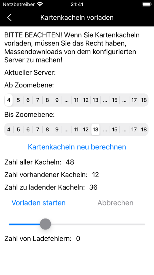
Choose your own tile server.
Preload tiles for offline use.
Set place markers, take photos, video, audios.
Write notes.
Record, import and export tracks in gpx format.
Backup and restore all your data.
Free use, no ads.
This app is open source. The code can be found at https://github.com/mr-elbe5/Maps-For-OSM-IOS.git
Further information on https://en.elbe5.de
ภาพหน้าจอ


ราคา
- วันนี้: ฟรี
- ต่ำสุด: ฟรี
- มากที่สุด: ฟรี
ติดตามราคา
ผู้พัฒนา
แต้มแล
-

- 1 cava tomi
- +1

การจัดอันดับ
ไม่พบ ☹️
รายการ
ไม่พบ ☹️
ความเห็น
แสดงรีวิวเป็นคนแรกเลย 🌟
ข้อมูลเพิ่มเติม
คุณอาจชอบ
- ใหม่
- OSM Maps
- macOS แอป: การนำทาง โดย: Michael Roennau
- ฟรี
- รายการ: 0 + 0 การจัดอันดับ: 0 ความเห็น: 0
- แต้มแล: 1 + 0 เวอร์ชัน: 1.1 This app shows OSM maps from a selectable sources (OSM or Elbe5). You can create notes add and edit photos and tracks in GPX format add record own tracks. It has list views of all ... ⥯
-
- Guru Maps Pro & GPS Tracker
- macOS แอป: การนำทาง โดย: Evgen Bodunov
- $89.99
- รายการ: 6 + 3 การจัดอันดับ: 0 ความเห็น: 0
- แต้มแล: 6 + 941 (4.7) เวอร์ชัน: 5.9.0 Discover detailed and user-friendly offline maps featuring millions of points of interest (POI). Record your GPS tracks and bookmark your favorite locations for easy access. OFFLINE ... ⥯
-
- Movies And Maps
- macOS แอป: การนำทาง โดย: Jan Nutbroek
- ฟรี
- รายการ: 2 + 0 การจัดอันดับ: 0 ความเห็น: 0
- แต้มแล: 7 + 0 เวอร์ชัน: 1.8 Movies And Maps plays your dash cam movies and plots the GPS route from the NMEA, GPX or BMW JSON log files on a map. The GPS position (and when available speed, altitude and ... ⥯
-
- Treasure Maps of WY
- macOS แอป: การนำทาง โดย: Todd Guion
- ฟรี
- รายการ: 0 + 0 การจัดอันดับ: 0 ความเห็น: 0
- แต้มแล: 0 + 0 เวอร์ชัน: 1.1 Treasure Maps of WY displays old WY maps as overlays on top of current street or satellite maps. This is possible because we georeference old maps, and offer them as in-app purchases. ... ⥯
-
- Private Maps
- macOS แอป: การนำทาง โดย: 64 Characters
- * ฟรี
- รายการ: 0 + 0 การจัดอันดับ: 0 ความเห็น: 0
- แต้มแล: 1 + 0 เวอร์ชัน: 1.1.1 The maps are based on OpenStreetMap data and style. Own servers are used to guarantee your privacy. Clean and minimalist interface. High-resolution detailed maps. The usage data is ... ⥯
-
- Topo GPS - Topographic maps
- macOS แอป: การนำทาง โดย: rdzl
- ฟรี
- รายการ: 0 + 0 การจัดอันดับ: 0 ความเห็น: 0
- แต้มแล: 2 + 402 (4.5) เวอร์ชัน: 10.5.0 Makes from your iPhone, iPad, Apple Watch and/or Macbook a complete GPS device with detailed topographic maps. Viewed maps will be stored on your device so that Topo GPS can also be ... ⥯
-
- Cartograph Maps 3
- macOS แอป: การนำทาง โดย: Harald Meyer
- ฟรี
- รายการ: 0 + 0 การจัดอันดับ: 0 ความเห็น: 0
- แต้มแล: 1 + 3 (4.3) เวอร์ชัน: 3.8.1 The Cartograph Maps app allows you to view Mapsforge offline vector maps and record tracks. It offers a variety of features such as viewing Mapsforge offline maps, support for ... ⥯
-
- Outside Maps
- macOS แอป: การนำทาง โดย: Replicade Ltd.
- ฟรี
- รายการ: 0 + 0 การจัดอันดับ: 0 ความเห็น: 0
- แต้มแล: 0 + 2 (2.0) เวอร์ชัน: 3.7.2 Please do not use reviews to report bugs or ask for features. I almost never read the reviews and I cannot contact you for additional information! Contact support@outsidemaps.com ... ⥯
-
- PopGIS - GeoJSON Maps + GIS
- macOS แอป: การนำทาง โดย: FreshBizOpps, LLC
- ฟรี
- รายการ: 0 + 0 การจัดอันดับ: 0 ความเห็น: 0
- แต้มแล: 1 + 0 เวอร์ชัน: 1.1 PopGIS is the simplest tool to view and edit GeoJSON files on your Mac. Open and edit geospatial datasets on your Mac using RFC 7946 compliant .json and .geojson files - import data ... ⥯
-
- GPS Tracks
- macOS แอป: การนำทาง โดย: David Morneault
- ฟรี
- รายการ: 6 + 1 การจัดอันดับ: 0 ความเห็น: 0
- แต้มแล: 9 + 15,970 (4.7) เวอร์ชัน: 4.9.6 "One of the better GPS apps for sporting enthusiasts for the iPhone..." - Bryan Wolfe, AppAdvice.com Do you want to track your hiking, biking, walking, running? Do you want to track ... ⥯
-
- Bit Map
- macOS แอป: การนำทาง โดย: NIXANZ
- * $3.99
- รายการ: 1 + 0 การจัดอันดับ: 0 ความเห็น: 0
- แต้มแล: 2 + 1 (5.0) เวอร์ชัน: 10.1 Bit Map provides mapping and navigation with offline maps (inc. JPEG, TIFF, PNG), online vector or raster map services (inc. WFS, WMTS, TMS, XYZ, OSM-compatible services), and offline ... ⥯
-
- Fast Fisk
- macOS แอป: การนำทาง โดย: Roger Hjartholm
- ฟรี
- รายการ: 1 + 0 การจัดอันดับ: 0 ความเห็น: 0
- แต้มแล: 10 + 0 เวอร์ชัน: 1.0 Track your fishing gear and report catch Easy to use throw out, and reel in Complete tracking database with iCloud support Track Crab, Lobster teine, net, hook and Line Track Boat ... ⥯
-
- OzRunways EFB
- macOS แอป: การนำทาง โดย: OzRunways Pty. Ltd.
- ฟรี
- รายการ: 0 + 0 การจัดอันดับ: 0 ความเห็น: 0
- แต้มแล: 0 + 142 (4.8) เวอร์ชัน: 13.2.1 OzRunways - Australia's #1 Electronic Flight Bag (EFB) is now available internationally. APPROVED BY Australian CASA under CASR 175. (See https://support.ozrunways.com/kb for ... ⥯
-
- i-Boating: WMTS-Marine & Lakes
- macOS แอป: การนำทาง โดย: Bist LLC
- ฟรี
- รายการ: 0 + 0 การจัดอันดับ: 0 ความเห็น: 0
- แต้มแล: 0 + 0 เวอร์ชัน: 137.0.0 The i-Boating WMTS is a dynamic web map tile service for private internal use that runs on your computer and provides coverage for marine charts and lake depth maps. It's the most ... ⥯