| Developer: | DA-PRDP GGU (6) | ||
| Price: | Free | ||
| Rankings: | 0 | ||
| Reviews: | 0 Write a Review | ||
| Lists: | 0 + 0 | ||
| Points: | 0 + 0 ¡ | ||
| Points + 1 | |||
Description
")
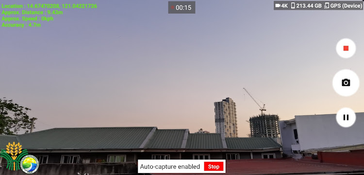
The PRDP AGT is one of the basic yet effective tools that the Project has pioneered and deployed nationwide, and is being adopted and used by partner Local Government Units (LGUs) and other national government agencies for their subproject monitoring and supervision. It has been lauded by the World Bank as a revolutionary and inexpensive approach to using Information and Communication Technology (ICT) and Global Positioning System (GPS) application for accurate visualization of sub-projects.
The creation of PRDP GeoCamera application will provide better real-time monitoring experience by providing the project with location based motion visual information of particular subproject activity to further strengthen transparency and accountability.
Screenshots


What's new
- Version: 2.8
- Updated:
- - Supports up to 4K Geo-Video Resolution
- Prevent usage of Fake Location Apps
- Auto-capture Geo-tagged Photos every 50 meters while recording Geo-Video
- View Geo-tagged photos into offline map
- Convert Geo-tagged photos into KMZ File
- Write Geo-Video location tag every 5 meters interval
- Auto-create new Geo-Video file when the current output reached the Android Maximum Video File Size Limit (3.5 GB or higher)
- Zoom Camera
- Application bug fixes
Price
- Today: Free
- Minimum: Free
- Maximum: Free
Track prices
Developer
- DA-PRDP GGU
- Platforms: Android Apps (6)
- Lists: 0 + 0
- Points: 0 + 0 ¡
- Rankings: 0
- Reviews: 0
- Discounts: 0
- Videos: 0
- RSS: Subscribe
Points
Not found ☹️
Rankings
Not found ☹️
Lists
Not found ☹️
Reviews
Be the first to review!
Additional Information
- Category:
Android Apps›Photography - OS:
Android 4.4 and up - Size:
19 Mb - Content Rating:
Everyone - Google Play Rating:
0 - Updated:
- Release Date:
You may also like
-
- GeoCamera
- Android Apps: Photography By: SweetApps QT
- * Free
- Lists: 0 + 0 Rankings: 0 Reviews: 0
- Points: 0 + 0 Version: 1.2.1 Combine Camera and GPS! Take pictures with the address of the place! GeoCamera use your Camera to take pictures and automatically indicates address (or name of the place know through ...
-
- Ifugao GeoCamera
- Android Apps: Tools By: DA-PRDP GGU
- Free
- Lists: 0 + 0 Rankings: 0 Reviews: 0
- Points: 0 + 0 Version: 1.2 The Ifugao GeoCamera is being used to provide accurate data and photo documentation of projects throughout their subproject cycle -- from identification, validation, procurement, ...
-
- DA GeoCamera
- Android Apps: Tools By: DA-PRDP GGU
- Free
- Lists: 0 + 0 Rankings: 0 Reviews: 0
- Points: 0 + 0 Version: 1.3 DA GeoCamera is being used to provide accurate data and photo documentation of projects throughout their subproject cycle -- from identification, validation, procurement, monitoring, ...
-
- DA GeoCamera - Advanced
- Android Apps: Photography By: DA-PRDP GGU
- Free
- Lists: 0 + 0 Rankings: 0 Reviews: 0
- Points: 0 + 0 Version: 4.0 Project management tool to enhance monitoring, governance, and quality investments supported by DA
-
- PCIP Planners App
- Android Apps: Tools By: DA-PRDP GGU
- Free
- Lists: 0 + 0 Rankings: 0 Reviews: 0
- Points: 0 + 0 Version: 1.3 It is an Android-based mobile application that can help planners to create an analysis for a particular commodity considering different types of parameters.
-
- DA-RFO1 ASF Monitoring Applica
- Android Apps: Tools By: DA-PRDP GGU
- Free
- Lists: 0 + 0 Rankings: 0 Reviews: 0
- Points: 0 + 0 Version: 1.5 DARFO1 ASF Monitoring Application is a mobile application used to monitor ASF-affected areas. This tool uses Applied Geotagging Technology (AGT) through capturing of geotagged photos ...
-
- HR Interview Practice
- Android Apps: Productivity By: Krishvi Software Solutions
- * Free
- Lists: 0 + 0 Rankings: 0 Reviews: 0
- Points: 0 + 0 Version: 5.0 Introducing HR Interview Practice app with most discussed HR round questions and interview tips. This application is one stop destination for all your HR Interview questions. This ...
-
- Easy Route Finder & Voice Maps
- Android Apps: Maps & Navigation By: Dictionary World11
- * * Free
- Lists: 0 + 0 Rankings: 0 Reviews: 0
- Points: 0 + 2,098 Version: 2.8 Easy Route Finder Voice Maps & GPS Navigation app is your one stop solution to all the traffic navigation needs. The app allows you to navigation your way to any destination across the