| ผู้พัฒนา: | OsmAnd (8) | ||
| ราคา: | ฟรี | ||
| การจัดอันดับ: | 0 | ||
| ความเห็น: | 0 เขียนความเห็น | ||
| รายการ: | 0 + 0 | ||
| แต้มแล: | 0 + 786 ¡ | ||
| แต้มแล + 1 | |||
คำอธิบาย
")
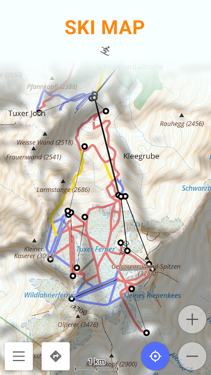
Usage Instructions: all pistes and ski map information is already available in the maps. Once you enable the plugin in OsmAnd application the ski maps will be enabled automatically. Ski maps are provided as a special map style and to switch style in OsmAnd please use the menu item 'Configure Map' on the map screen.
In case you would like to get to the default map style please disable the plugin or change the map style
ภาพหน้าจอ


มีอะไรใหม่
- เวอร์ชัน: 1.0
- อัปเดต:
- Update Target API Level
ราคา
- วันนี้: ฟรี
- ต่ำสุด: ฟรี
- มากที่สุด: ฟรี
ติดตามราคา
ผู้พัฒนา
แต้มแล
ไม่พบ ☹️
การจัดอันดับ
ไม่พบ ☹️
รายการ
ไม่พบ ☹️
ความเห็น
แสดงรีวิวเป็นคนแรกเลย!
ข้อมูลเพิ่มเติม
- หมวดหมู่:
Android แอป›การเดินทางและท้องถิ่น - ระบบปฏิบัติการ:
Android 4.0.3 และสูงกว่า - ขนาด:
15 Mb - การจัดประเภทเนื้อหา:
Everyone - Google Play คะแนนโดย:
4.4(786) - อัปเดต:
- วันที่วางจำหน่าย:
รายชื่อติดต่อ
- เว็บไซท์:
 http://osmand.net
คุณอาจชอบ
-
- Contour lines plugin — OsmAnd
- Android แอป: การเดินทางและท้องถิ่น โดย: OsmAnd
- $4.99
- รายการ: 0 + 0 การจัดอันดับ: 0 ความเห็น: 0
- แต้มแล: 0 + 2,128 เวอร์ชัน: 1.0 Contour lines plugin OsmAnd is a plugin for 'Maps & Navigation OsmAnd' app. The plugin provides extremely detailed offline topo maps that can be zoomed in and out without losing the ...
-
- Ski amadé Guide
- Android แอป: การเดินทางและท้องถิ่น โดย: Ski amadé
- ฟรี
- รายการ: 0 + 0 การจัดอันดับ: 0 ความเห็น: 0
- แต้มแล: 0 + 2,243 เวอร์ชัน: 0.1.8.240216 Ski amadé Guide - Smart helper for your jacket pocket The best helper for your ski holiday - with the mobile App "Ski amadé Guide" you are always up-to-date and well-informed: photo ...
-
- Map of London offline
- Android แอป: การเดินทางและท้องถิ่น โดย: Map Apps
- * * ฟรี
- รายการ: 0 + 0 การจัดอันดับ: 0 ความเห็น: 0
- แต้มแล: 0 + 1,756 เวอร์ชัน: 4.8 Map of London offline works without connecting to the Internet. No need to pay for internet in roaming. Benefits Map of London offline: - Ease of Use - Highly detailed maps are adapted
-
- Ski Utah
- Android แอป: การเดินทางและท้องถิ่น โดย: Ski Utah
- * ฟรี
- รายการ: 0 + 0 การจัดอันดับ: 0 ความเห็น: 0
- แต้มแล: 0 + 576 เวอร์ชัน: 8.0.23 Updated and deeper than ever, the Ski Utah app is your only friend on powder days. Ever wonder how much fresh powder you skied over the season, how many days you racked-up, wonder no ...
-
- GPS on ski map
- Android แอป: การเดินทางและท้องถิ่น โดย: Maprika
- ฟรี
- รายการ: 0 + 0 การจัดอันดับ: 0 ความเห็น: 0
- แต้มแล: 0 + 1,225 เวอร์ชัน: New Maprika is the best mapping solution for ski resorts, parks, and campuses. Maprika uses GPS to put a "You are here" sign on "paper" maps, just like the ones you get at ski resort ...
-
- GPS Navigation Live Map Road
- Android แอป: การเดินทางและท้องถิ่น โดย: Map Zone Studio
- * * ฟรี
- รายการ: 0 + 0 การจัดอันดับ: 0 ความเห็น: 0
- แต้มแล: 0 + 28,948 เวอร์ชัน: 4.1.6 Discover seamless exploration with the ultimate GPS Navigation & Map Direction App. This lightweight free navigation app helps you find the shortest route to your destination, avoid ...
-
- Map.md - map of Moldova
- Android แอป: การเดินทางและท้องถิ่น โดย: Simpals SRL
- ฟรี
- รายการ: 0 + 0 การจัดอันดับ: 0 ความเห็น: 0
- แต้มแล: 0 + 3,985 เวอร์ชัน: 9.0 Map.md is a vector map of Moldova, which includes a detailed catalogue of places and institutions, easy and simple search system, comfortable navigation and public transport routes. ...
-
- GPS Map Camera Geotag Location
- Android แอป: การเดินทางและท้องถิ่น โดย: Tools Village - GPS_Map_Camera, GPS_Speedometer
- * * ฟรี
- รายการ: 0 + 0 การจัดอันดับ: 0 ความเห็น: 0
- แต้มแล: 0 + 2,947 เวอร์ชัน: 1.84 Auto GPS Map Camera is here to Add Geotag Location on Photos. Track your current GPS Location, save it and even share. It has become easy with this gps camera location Application & ...
-
- Map Location Timeline
- Android แอป: การเดินทางและท้องถิ่น โดย: Stupendous Andro
- * * ฟรี
- รายการ: 0 + 0 การจัดอันดับ: 0 ความเห็น: 0
- แต้มแล: 0 + 630 เวอร์ชัน: 1.25 App features in short : - Get daily track of places you have visited on map with route. - Get time and duration of all places visited in a day. - Get historical data of all previous ...
-
- Ski Serbia
- Android แอป: การเดินทางและท้องถิ่น โดย: Flixeron
- * ฟรี
- รายการ: 0 + 0 การจัดอันดับ: 0 ความเห็น: 0
- แต้มแล: 0 + 31 เวอร์ชัน: 1.0.23 Discover the thrill of skiing in Serbia with the Serbian Ski Resorts App! Immerse yourself in the beauty of Kopaonik, Stara Planina, and Tornik ski resorts. Our app provides real-time ...
-
- Crystal Ski Explorer
- Android แอป: การเดินทางและท้องถิ่น โดย: Crystal Ski Holidays
- ฟรี
- รายการ: 0 + 0 การจัดอันดับ: 0 ความเห็น: 0
- แต้มแล: 0 + 637 เวอร์ชัน: 7.2.0 Google Play Store Description: Expert info, tips on the go and easy ski planning across our 120+ resorts, at just a tap. Our Ski Explorer app puts the mountain in your pocket: Resort ...
-
- Ski Arlberg
- Android แอป: การเดินทางและท้องถิ่น โดย: intermaps
- ฟรี
- รายการ: 0 + 0 การจัดอันดับ: 0 ความเห็น: 0
- แต้มแล: 0 + 242 เวอร์ชัน: 3.6 (0.0.151) The interactive real-time ski guide for Ski Arlberg with all the latest data, from intermaps: - Where am I? Direct positioning on the skimap and map. - Navigation with the brandnew ...
-
- Map It Vilas County
- Android แอป: การเดินทางและท้องถิ่น โดย: Pilch & Barnet, Inc.
- ฟรี
- รายการ: 0 + 0 การจัดอันดับ: 0 ความเห็น: 0
- แต้มแล: 0 + 56 เวอร์ชัน: 3.92 Explore dozens of public recreational trails in Vilas County, Wisconsin, with this app. Interactive maps help you explore the best spots for biking, hiking, cross-country skiing and ...
-
- GPS Navigation: Live Earth Map
- Android แอป: การเดินทางและท้องถิ่น โดย: Tap Apps Studio
- * ฟรี
- รายการ: 0 + 0 การจัดอันดับ: 0 ความเห็น: 0
- แต้มแล: 0 + 7,187 เวอร์ชัน: 1.7.9 GPS Navigation Live Street Map and Driving Direction allow you to make driving route on world map. With GPS navigation app & street view maps helps you to visit any famous place of ...