| 개발자: | Mapnitude Company Limited (14) | ||
| 가격: | 무료 | ||
| 순위: | 0 | ||
| 리뷰: | 0 리뷰 작성 | ||
| 목록: | 0 + 0 | ||
| 포인트: | 0 + 4,785 (4.5) ¡ | ||
| App Store | |||
기술
")
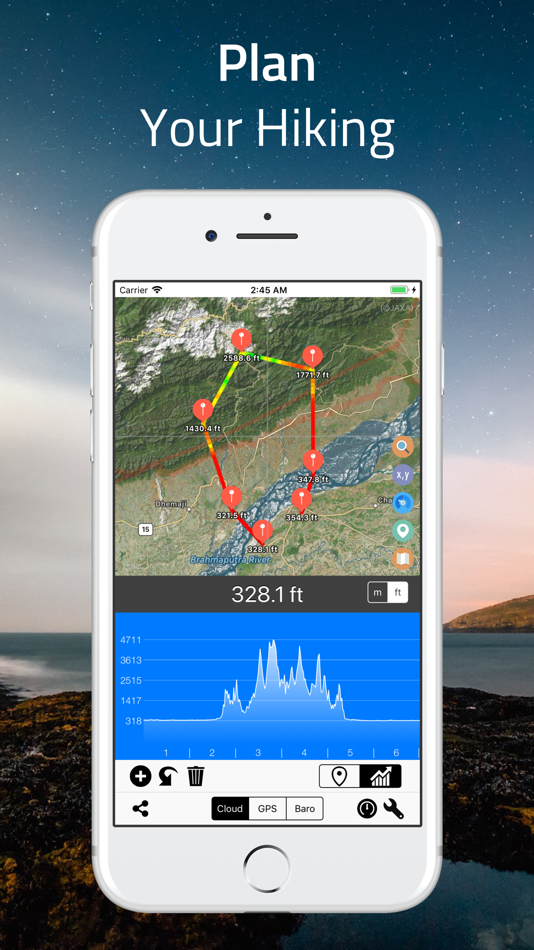
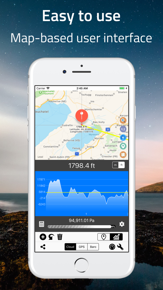
## Elevation Finder ##
This app helps you observe the elevations of all locations on the surface of the earth by simply touch and move the map around, or input the address/location name. You can also find the elevation of your current location by using online database, built-in GPS, or barometer on your device.
Elevation data benefits flood prevention, prediction of water levels in rivers, lakes, and seas, etc. Thus, knowing the elevation of places is very crucial if you are looking for a flood-free house, or planning for a hiking trip, and more.
## Cloud-based Altitude Data ##
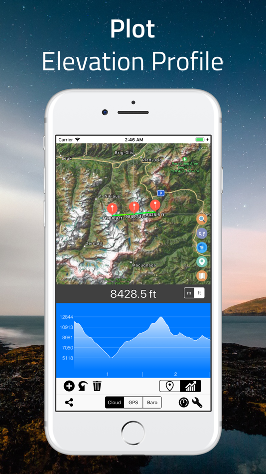
The easiest way to find altitude of any location on earth. By simply point on the screen, you can get the elevation data from a coordinate location point. “Range Mode” is available for altitude comparison (by graph and line) of each point between two selected locations.
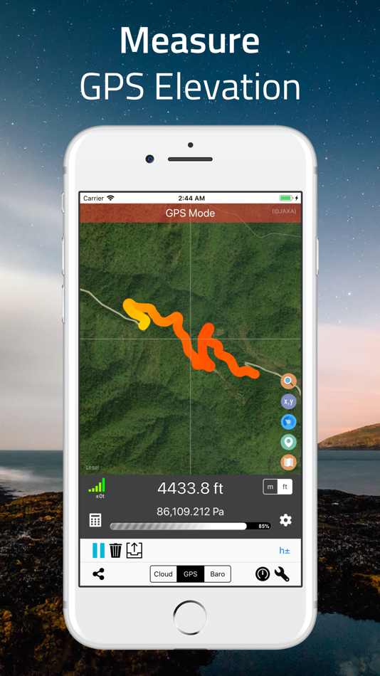
## GPS Altitude Data ##
Use built-in GPS on your device to determine the altitude of your current location. The altitude data of the area you walked-through will be recorded and displayed as a multicolored line on the map. The colors presented on the line indicate different heights. Precision indicators (horizontal resolution and vertical resolution) are displayed on the screen.
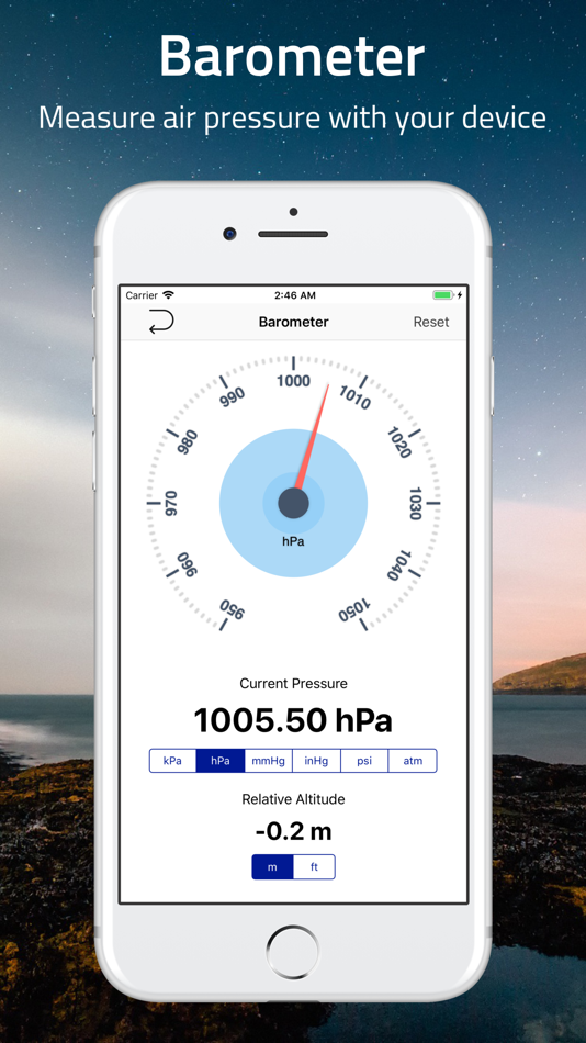
## Barometric Altitude Data ##
Use built-in barometer on your device to determine the elevation of your current location. You can either measure the elevation from raw barometric data, or relative pressure from sea-level. Like GPS data, the result is displayed as a multicolored line.
To get the most accurate data, it is recommended to adjust the sea level pressure and temperature prior to the measurement, and set the offset or calibration value if necessary.
## Standalone Barometer ##
You can use this app as a standalone barometer.
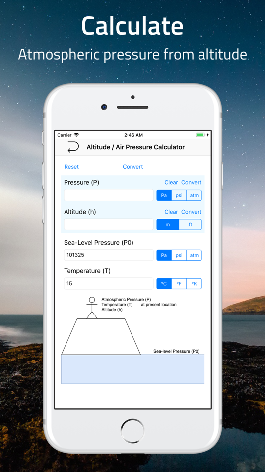
## Air Pressure / Altitude Calculator ##
Atmospheric pressure and/or altitude at your current location are calculated from known altitude, pressure of the location, temperature and/or sea level pressure.
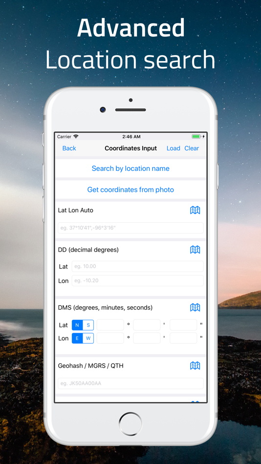
## Support of Coordinate Formats ##
This app not only displays regular latitude and longitude data, but also supports many coordinate systems such as, Universal Transverse Mercator (UTM) coordinate system and Military Grid Reference System (MGRS) and more.
## Export of Data ##
From this app, you can export many useful information including timestamp, altitude, pressure, and coordinates.
Subscription
-------------
Elevation - Sea Level Map is completely free to use with all features. You can subscribe to this application to remove ads and reduce data retrieving delay by 50%.
Device subscriptions are available in these plan and will renew automatically each month, six months or year, unless cancelled.
(Per month) - $4.49
(Per six-months) - $25.99
(Per year) - $48.99
Pricing shown is for the United States store. Pricing in other stores will vary.
Payment for subscriptions will be charged to your iTunes Account at confirmation of purchase
Account will be charged for renewal within 24-hours prior to the end of the current period. Subscription automatically renews unless auto-renew is turned off at least 24-hours before the end of the current period
Subscriptions may be managed by going to your iTunes Account Settings after purchase or by clicking the “Purchase / Manage Subscription. Auto-renewal may be turned off by going to Account Settings after purchase.
Subscription cannot be cancelled during the active subscription period
More information: https://mapnitude.com/elevation
Privacy policy: https://mapnitude.com/privacy-policy
Terms of use: https://mapnitude.com/terms-of-service
스크린샷
가격
- 오늘: 무료
- 최소: 무료
- 최대: 무료
가격 추적
개발자
- Mapnitude Company Limited
- 플랫폼: iOS 앱 (14)
- 목록: 0 + 1
- 포인트: 13 + 14,629 ¡
- 순위: 0
- 리뷰: 0
- 할인: 0
- 동영상: 0
- RSS: 구독
포인트
0 ☹️
순위
0 ☹️
목록
0 ☹️
리뷰
첫 번째 리뷰를 남겨보세요 🌟
추가 정보
주소록
당신은 또한 같은 수 있습니다
-
- Altimeter+
- iOS 앱: 내비게이션 게시자: Sichtwerk AG
- $0.99
- 목록: 0 + 1 순위: 0 리뷰: 0
- 포인트: 0 + 666 (4.5) 버전: 2.6 The Altimeter+ altimeter calculates the altitude of your current location via a GPS, Aster or barometer measurement (for iPhone 6 and later). In addition to this, the app also provides ⥯
-
- Altimeter for Aviators
- iOS 앱: 내비게이션 게시자: STEARsoft
- 무료
- 목록: 0 + 0 순위: 0 리뷰: 0
- 포인트: 0 + 553 (4.7) 버전: 2.6 If you want a 'real' Altimeter, look no further. No GPS used here. Learn how a real pressure Altimeter works such as you would find in an aircraft. Altimeter for Aviators is primarily ... ⥯
-
- Altimeter: Elevation, Compass
- iOS 앱: 내비게이션 게시자: Furkan Ozoglu
- 무료
- 목록: 0 + 0 순위: 0 리뷰: 0
- 포인트: 1 + 1,181 (4.7) 버전: 2.1 While traveling with a vehicle (car, bicycle, etc.), while hiking or climbing, you can instantly discover your location and altitude, direction, geographic coordinate, address and ... ⥯
-
- Altimeter GPS & Barometer
- iOS 앱: 내비게이션 게시자: Andrea Terdich
- 무료
- 목록: 0 + 0 순위: 0 리뷰: 0
- 포인트: 0 + 1,758 (4.6) 버전: 7.2 Unlock the full potential of your iPhone's sensors for your wilderness adventures and survival situations with Altimeter GPS. This app is thoughtfully designed for offline use, ... ⥯
-
- Map Plus
- iOS 앱: 내비게이션 게시자: Miocool Inc.
- 무료
- 목록: 1 + 1 순위: 0 리뷰: 0
- 포인트: 0 + 613 (4.6) 버전: 2.9.0 The most powerful and versatile tool for viewing and editing custom maps, surveying, editing or managing mass of your geography data. You can use Map Plus as a professional GIS tool ... ⥯
-
- Trucker Path: Truck GPS & Map
- iOS 앱: 내비게이션 게시자: Trucker Path Inc.
- 무료
- 목록: 1 + 0 순위: 0 리뷰: 0
- 포인트: 0 + 123,657 (4.8) 버전: 6.7.8 North America s most popular app for Truckers. BUILT FOR TRUCKERS, BY TRUCKERS! Get all trucker tools in one FREE APP! Best Trucking APP featured by truckers! Trucker Path is a mapping ⥯
-
- New York Subway MTA Map NYC
- iOS 앱: 내비게이션 게시자: Mapway Limited
- 무료
- 목록: 0 + 0 순위: 0 리뷰: 0
- 포인트: 0 + 107,453 (4.6) 버전: 5.5.6 New York Subway uses the official MTA subway map and includes a helpful transit route planner. With over 12 million downloads worldwide this NYC subway map is free to download and will ⥯
-
- My Altitude and Elevation GPS
- iOS 앱: 내비게이션 게시자: MYSTIC MOBILE APPS LLC
- 무료
- 목록: 0 + 0 순위: 0 리뷰: 0
- 포인트: 2 + 1,101 (4.6) 버전: 6.47 With our app, measuring altitude and elevation is easier than ever. - High-Precision Altitude & Elevation Tracking: Seamlessly monitor your current altitude and elevation with ... ⥯
-
- NYC Precinct Map
- iOS 앱: 내비게이션 게시자: JC Accounting & Innovative Technologies, Inc
- 무료
- 목록: 0 + 0 순위: 0 리뷰: 0
- 포인트: 0 + 986 (4.9) 버전: 3.0 Interactive map of New York City showing all Precinct and Precinct Sector boundaries with crime/incident info. Features Include: Know your location...Displays and/or speaks your ... ⥯
-
- Travel Altimeter & Elevation
- iOS 앱: 내비게이션 게시자: BranchenKing Ltd.
- 무료
- 목록: 0 + 0 순위: 0 리뷰: 0
- 포인트: 0 + 41,242 (4.7) 버전: 6.13 View your altitude or elevation on stunning landscapes that adjust with the time of day. The barometer lets you track your altitude changes based on the change of pressure. Just set ... ⥯
-
- My Altitude: GPS Altimeter
- iOS 앱: 내비게이션 게시자: Gaurav Babbar
- 무료
- 목록: 1 + 1 순위: 0 리뷰: 0
- 포인트: 1 + 8,333 (4.6) 버전: 2.6 Download now the best Altimeter app for Hikers, Trekkers, and GlobeTrotters. Altimeter GPS is a multipurpose app equipped with features like an altimeter, barometer, compass over your ... ⥯
-
- Aqua Map Boating
- iOS 앱: 내비게이션 게시자: GEC s.r.l.
- 무료
- 목록: 0 + 0 순위: 0 리뷰: 0
- 포인트: 0 + 12,036 (4.7) 버전: 51.1 Free 14-day trial for all subscriptions Aqua Map offers weekly updated OFFICIAL NAUTICAL CHARTS (NOAA) for marine navigation. Purchase a chart subscription for the area of your ... ⥯
-
- Supercharger map for Tesla
- iOS 앱: 내비게이션 게시자: yohan teixeira
- 무료
- 목록: 0 + 0 순위: 0 리뷰: 0
- 포인트: 0 + 11,949 (4.7) 버전: 4.8 Supercharger for Tesla is an essential tool for any Tesla owner. With this app, you can easily find a supercharger station near you, so you never have to worry about running out of ... ⥯
-
- Terrain Radar Altimeter
- iOS 앱: 내비게이션 게시자: Nestele Engineering
- 무료
- 목록: 0 + 0 순위: 0 리뷰: 0
- 포인트: 0 + 711 (4.7) 버전: 2.8.0 Measure the elevation of each location within a radius of 500 meter. With Terrain Radar Altimeter you can discover the height of hills in front of you or take a look at further away ... ⥯