| 개발자: | BranchenKing Ltd. (1) | ||
| 가격: | 무료 | ||
| 순위: | 0 | ||
| 리뷰: | 0 리뷰 작성 | ||
| 목록: | 0 + 0 | ||
| 포인트: | 0 + 37,624 ¡ | ||
| 포인트 + 1 | |||
기술
")
5-Star Reviews:
"I love this app, wherever I go snowmobiling or hiking I always use it."
"This app really works well. I enjoy checking the altitude wherever I am. Nice!"
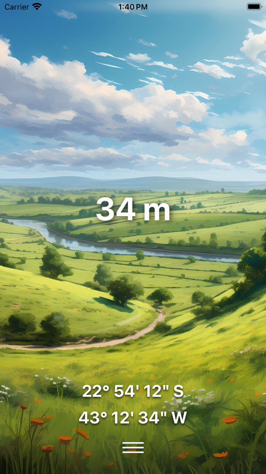
A simple and uncluttered interface to read:
• Altitude or Elevation
• Latitude
• Longitude
Features
• Highest GPS accuracy for your device
• Ground elevation from topographical map values
• View in feet or meters
• Built-in flashlight
Sharing
• Share screenshots with beautiful backgrounds
• Share on Twitter, Facebook, Instagram, Email, or text message
Use the Custom Background upgrade to take a photo from the top of a mountain and take a screenshot with your altitude overlaid to show your family & friends.
Backgrounds (In-App purchases):
• Meadow landscape (Illustrated)
• Cityscape (Illustrated)
• Mountains (Illustrated)
• Abstract
• Choose Your Own
Note: Many customers with high altitude illnesses or sensitivities, such as chronic lung disease, asthma, COPD, & emphysema find this app useful for avoiding high altitudes. It is also used by hikers and climbers who want to avoid high-altitude cerebral edema (HACE) and high-altitude pulmonary edema (HAPE). However, the altitude shown is potentially subject to large inaccuracies and this app should NOT be used as a primary device for determining altitude for medical reasons.
스크린샷


새로운 기능
- 버전: 5.6
- 업데이트:
- minor update
가격
- 오늘: 무료
- 최소: 무료
- 최대: 무료
가격 추적
개발자
- BranchenKing Ltd.
- 플랫폼: iOS 앱 (1)
- 목록: 0 + 0
- 포인트: 0 + 37,624 ¡
- 순위: 0
- 리뷰: 0
- 할인: 0
- 동영상: 0
- RSS: 구독
포인트
찾을 수 없음 ☹️
순위
찾을 수 없음 ☹️
목록
찾을 수 없음 ☹️
리뷰
첫 번째 리뷰를 남겨보세요!
추가 정보
- 카테고리:
iOS 앱›내비게이션 - 운영체제:
iPad,iPhone,iOS 16.0 이상 - 크기:
93 Mb - 지원되는 언어:
Arabic,Chinese,Croatian,Czech,Danish,Dutch,English,Finnish,French,German,Greek,Hebrew,Hungarian,Indonesian,Italian,Japanese,Korean,Malay,Norwegian,Polish,Portuguese,Romanian,Russian,Slovak,Spanish,Swedish,Thai,Turkish,Ukrainian,Vietnamese - 콘텐츠 등급:
4+ - App Store 개의 평가:
4.7(37,624) - 업데이트:
- 출시일:
주소록
당신은 또한 같은 수 있습니다
-
- Altimeter: Elevation, Compass
- iOS 앱: 내비게이션 게시자: Furkan Ozoglu
- 무료
- 목록: 0 + 0 순위: 0 리뷰: 0
- 포인트: 0 + 934 버전: 2.0.3 While traveling with a vehicle (car, bicycle, etc.), while hiking or climbing, you can instantly discover your location and altitude, direction, geographic coordinate, address and ...
-
- Elevation - Altimeter Map
- iOS 앱: 내비게이션 게시자: Mapnitude Company Limited
- * 무료
- 목록: 0 + 1 순위: 0 리뷰: 0
- 포인트: 0 + 4,341 버전: 4.9.15 Find your current elevation, altitude, and height above sea level easily with this altimeter/barometer app. ## Elevation Finder ## This app helps you observe the elevations of all ...
-
- Altimeter & Precision - Simple
- iOS 앱: 내비게이션 게시자: Studio Nano Ship, Inc.
- $0.99
- 목록: 0 + 0 순위: 0 리뷰: 0
- 포인트: 2 + 1,253 버전: 3.8.0 Thousands of users have trusted our altimeter for 7 years. This application is made in Montreal. No data collected or shared. For the price of a coffee, support us! Thank you very ...
- 새로운
- My Altitude and Elevation GPS
- iOS 앱: 내비게이션 게시자: MYSTIC MOBILE APPS LLC
- * 무료
- 목록: 0 + 0 순위: 0 리뷰: 0
- 포인트: 0 + 1,095 버전: 6.11 Displays: 1. Latitude and longitude in following formats: - DMS degrees, minutes and seconds sexgesimal - DDM degrees and decimal minutes - DD decimal degrees - UTM Universal ...
-
- My Altitude: GPS Altimeter
- iOS 앱: 내비게이션 게시자: Gaurav Babbar
- 무료
- 목록: 0 + 2 순위: 0 리뷰: 0
- 포인트: 1 + 7,687 버전: 2.6 Download now the best Altimeter app for Hikers, Trekkers, and GlobeTrotters. Altimeter GPS is a multipurpose app equipped with features like an altimeter, barometer, compass over your ...
-
- Compass & Altimeter
- iOS 앱: 내비게이션 게시자: 明力 王
- * 무료
- 목록: 0 + 0 순위: 0 리뷰: 0
- 포인트: 0 + 1,465 버전: 1.0.9 Compass GPS is an application for measuring geographical orientation. It also supports many data displays, including altitude, longitude and latitude, weather, water boiling point, air
-
- Japan Travel - Route,Map,Guide
- iOS 앱: 내비게이션 게시자: NAVITIME JAPAN CO.,LTD.
- * 무료
- 목록: 0 + 0 순위: 0 리뷰: 0
- 포인트: 0 + 1,760 버전: 5.8.0 Japan Travel by NAVITIME will help you travel around like a local! App Overview: -Explore (Travel guides/articles) -Route Search -Map / Offline Spot Search -Plan About the Features: ...
-
- Atlas Obscura Travel Guide
- iOS 앱: 내비게이션 게시자: Atlas Obscura, Inc
- 무료
- 목록: 0 + 0 순위: 0 리뷰: 0
- 포인트: 0 + 5,738 버전: 1.6.2 Find your adventurous spirit, get off the beaten path and discover unique places to experience near and far, all contributed by Atlas Obscura s global community of explorers. EXPLORE ...
-
- Footpath Route Planner
- iOS 앱: 내비게이션 게시자: Half Mile Labs LLC
- 무료
- 목록: 2 + 1 순위: 0 리뷰: 0
- 포인트: 1 + 17,015 버전: 4.9.15 Map routes with your finger and Footpath will snap to roads and trails. Measure distances and elevations in seconds, then navigate along with turn-by-turn directions. Footpath is the ...
-
- TfL Go: Live Tube, Bus & Rail
- iOS 앱: 내비게이션 게시자: TfL
- 무료
- 목록: 0 + 1 순위: 0 리뷰: 0
- 포인트: 0 + 5,638 버전: 1.62.0 Travel confidently around London with maps and live travel updates on our official TfL app. Check live arrival times for Tube, London Overground, DLR, Elizabeth line and Thameslink ...
-
- Density Altitude +
- iOS 앱: 내비게이션 게시자: Rate Of Climb Industries
- $3.99
- 목록: 0 + 0 순위: 0 리뷰: 0
- 포인트: 0 + 838 버전: 2.7 Instant and location accurate Density Altitude calculator/instrument app for iPhone and iPad that also finds relative air density (RAD), altimeter setting, relative humidity, specific ...
-
- Commander Compass Go
- iOS 앱: 내비게이션 게시자: Pavel Ahafonau
- 무료
- 목록: 0 + 0 순위: 0 리뷰: 0
- 포인트: 0 + 7,179 버전: 3.17 Commander Compass is an essential offline GPS app for outdoors and off-road navigation. Packed with tools it serves as a hi-tech compass with maps, gyrocompass, GPS receiver, waypoint ...
-
- inRoute - Intelligent Routing
- iOS 앱: 내비게이션 게시자: Carob Apps, LLC
- * 무료
- 목록: 0 + 0 순위: 0 리뷰: 0
- 포인트: 0 + 7,846 버전: 8.4.4 Plan optimal routes or chart your own course using weather, elevation, curves and more. Then navigate safely with voice-guided, turn-by-turn directions that automatically check your ...
-
- My Altitude
- iOS 앱: 내비게이션 게시자: Dayana Networks Ltd
- 무료
- 목록: 0 + 0 순위: 0 리뷰: 0
- 포인트: 0 + 22,399 버전: 2.8.3 My Altitude uses GPS signals to determine your current location, showing your latitude, longitude and altitude (height from sea level) barometric pressure and water boiling point. It's