| ผู้พัฒนา: | James Associates Inc. (4) | ||
| ราคา: | $1.99 | ||
| การจัดอันดับ: | 0 | ||
| ความเห็น: | 0 เขียนความเห็น | ||
| รายการ: | 0 + 0 | ||
| แต้มแล: | 1 + 0 ¡ | ||
| App Store | |||
คำอธิบาย
")
Caught in a storm on the water and your chart plotter fails? Don't worry! Download this app now and regain navigation capabilities to safely return to port. Better yet, buy iSailGPS NZ today ensuring you're prepared for any situation, even in areas with no cell service.
One Low Price! Everything included. No sign-ups, ads, subscriptions or in-app purchases. Completely respects your privacy.
Unrivaled Features to Enhance Your Journey:
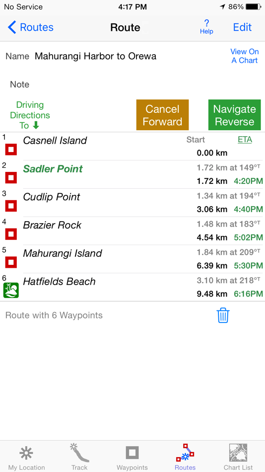
TRACKS, WAYPOINTS & ROUTES
Record tracks as you sail, even in the background. View them on the chart and in a Speed & Course Over Ground graph.
Mark waypoints precisely using charts or satellite maps, place names or addresses, geotagged photos, or by projecting from a known point.
Set a quick GoTo waypoint or a full route and see the course (COG), heading (HDG), bearing (BRG), direction, distance, cross track error (XTE), Velocity Made Good (VMG) and Estimated Time of Arrival (ETA) at your destination and intermediate points. Perfect for racing enthusiasts.
In a Man Overboard (MOB) emergency a single button press marks your current position & starts navigating to it.
Create customized routes using waypoints, recorded tracks, or imported GPX, KML or TCX files. Advanced route editing.
Send GPX and KML waypoint, route, track and map list files via AirDrop, eMail, Messages or iCloud Drive.
View the sun & moon position and rise & set times for any date and place on earth.
Send data to other apps such as Google Earth.
LAND INFORMATION NEW ZEALAND RNC MARINE CHARTS
Access all LINZ NZ Raster Nautical Charts with no extra charge. These charts had their final update on 7/12/23. There will be no further updates.
Our charts are optimized to download faster using WiFi or cell service. Store a few charts or charts for the whole country to use anytime without cell service.
Stitches Mercator charts & automatically switches between downloaded charts as you sail. Choose detailed or overview charts.
Enjoy the high resolution and what's-all-around detail of these NZ Nautical Charts (RNC). They are a welcome advantage over Vector Charts, which only show a coastline, depths, navigation aids, and minimal details.
Print and Share chart images overlaid with waypoints, routes & tracks.
Measure distance between any two points.
USE YOUR PREFERRED UNITS
Kilometers, Miles or Nautical Miles.
Meters or Feet.
Degrees, Degrees/Minutes, Degrees/Minutes/Seconds, UTM or NZTM2000 grid.
°True or °Magnetic.
HOW TOS
Tap Help in the app.
Online Manual: iSailGPS.com/nz
Email developer: lwjames@isailgps.com
RASTER CHARTS vs. VECTOR CHARTS
The Land Information New Zealand Raster Nautical Charts in iSailGPS NZ differ from computer-drawn vector ENC charts in that each chart covers a specific area, the same way a paper nautical chart does. Switches automatically to a new chart when you leave the area covered by the previous chart. For many locations, there are multiple charts at different scales with different levels of detail & areas of coverage.
Paper charts can contain multiple panels, each showing a different area or scale. Each digital panel is individually displayed by iSailGPS NZ with a north-up orientation.
iSail GPS NZ is priced to make it readily available to all boating enthusiasts.
iSailGPS NZ and the charts that it includes do NOT meet the legal requirements for navigation using charts that you may be required to carry.
DEVICE REQUIREMENTS
Use iSailGPS on any iOS device even if you don't have a cellular data plan for it. iPhones & WiFi+cellular iPads support all features. For WiFi-only iPads, an iOS-compatible external GPS receiver is required to show your location & record tracks. You can view charts using the iOS device alone.
Discover a safer and more enjoyable sailing experience with iSailGPS NZ!
ภาพหน้าจอ


มีอะไรใหม่
- เวอร์ชัน: 9.6.6
- อัปเดต:
- Updated for iOS 26.1. We're regularly improving this app so it will be even more useful!
What's new in iSailGPS NZ when compared with other available New Zealand chart apps?
You don't just see waypoints and routes displayed on the chart, you can actually do real great circle navigation to those waypoints and along those routes. You get information such as Estimated Time of Arrival, current bearing, heading and cross-track error, and remaining distances to your intermediate and final destinations.
You can create, import, edit, export, and navigate both on routes based on a recorded or imported path, and on routes based on a series of waypoints.
Get the weather report and forecast, the sun and moon position, rise and set times, and driving directions to the dock for any point on a chart with a few taps.
iSailGPS NZ's code size is kept very small by efficient programming so in an emergency, you can download it easily even over a weak cell connection.
The current version of iSailGPS NZ runs on the latest devices and also on older devices with older versions of iOS , all the way back to devices such as the iPhone 6.
Check the App Privacy section. We don't know who you are when you are using iSailGPS NZ. We never send your current location or your recorded track to our servers. Hence we cannot and don't use your location data. We cannot and don't provide your location data to anyone else. Unlike other mapping apps that profit from using your location data in ways that do not keep it private, iSailGPS NZ maintains the highest level of data confidentially.
ราคา
- วันนี้: $1.99
- ต่ำสุด: $0.99
- มากที่สุด: $5.99
ติดตามราคา
ผู้พัฒนา
- James Associates Inc.
- แพลตฟอร์ม: iOS แอป (4)
- รายการ: 0 + 0
- แต้มแล: 2 + 131 ¡
- การจัดอันดับ: 0
- ความเห็น: 0
- ลดราคา: 0
- วิดีโอ: 0
- RSS: ติดตาม
แต้มแล
-

- 91 Taban Bovin
- +1

การจัดอันดับ
0 ☹️
รายการ
0 ☹️
ความเห็น
แสดงรีวิวเป็นคนแรกเลย 🌟
ข้อมูลเพิ่มเติม
รายชื่อติดต่อ
- เว็บไซท์:
 http://iSailGPS.com/nz
- 🌟 แชร์
- App Store
คุณอาจชอบ
-
- Nautical Charts & Maps
- iOS แอป: การนำทาง โดย: LW Brands, LLC
- $8.99
- รายการ: 0 + 0 การจัดอันดับ: 0 ความเห็น: 0
- แต้มแล: 0 + 3,717 (4.6) เวอร์ชัน: 1.14 Main Features Include: + NOAA Electronic Navigational Charts (ENC) + NOAA Weather Map Overlays -- ELECTRONIC NAVIGATION CHARTS -- Electronic Navigational Charts (ENC) are vector data ... ⥯
-
- Great Lakes HD Nautical Charts
- iOS แอป: การนำทาง โดย: Flytomap
- * $14.99
- รายการ: 0 + 0 การจัดอันดับ: 0 ความเห็น: 0
- แต้มแล: 1 + 7 (2.1) เวอร์ชัน: 5.9.1 Flytomap is a valid and interesting alternative, Benetti Yachts Top Ten since 2008 Featured in : On the Deck Great Lakes - The whole coverage resident in the app. It works WITHOUT ... ⥯
-
- Nautical Calculator Preview
- iOS แอป: การนำทาง โดย: The Vu Cong
- ฟรี
- รายการ: 0 + 0 การจัดอันดับ: 0 ความเห็น: 0
- แต้มแล: 0 + 1 (5.0) เวอร์ชัน: 7.2.7 The application to assist in solving the most important marine problems. - For Marine Navigation +Real-Time Ship Movement; +Route Plan; + Mercator Sailing. + Greate Circle Sailing. + ... ⥯
-
- Nautical Calculator Pro
- iOS แอป: การนำทาง โดย: Giacomo Gabriele
- $8.99
- รายการ: 0 + 0 การจัดอันดับ: 0 ความเห็น: 0
- แต้มแล: 0 + 3 (5.0) เวอร์ชัน: 12.1.0 Nautical Calculator Pro is the most complete application that solves the navigation calculations The main features are : - Calculate Route (solves 2nd navigation problem) - Calculate ... ⥯
-
- Nautical Nomograph
- iOS แอป: การนำทาง โดย: Universal Queue LLC
- $4.99
- รายการ: 0 + 0 การจัดอันดับ: 0 ความเห็น: 0
- แต้มแล: 0 + 4 (5.0) เวอร์ชัน: 1.0 Nautical Nomograph is your go-to tool for quick time-speed-distance calculations. Say goodbye to tedious math; this app turns a traditionally mundane task into an engaging experience. ... ⥯
-
- NZ Charts
- iOS แอป: การนำทาง โดย: Right Place Resources
- $2.99
- รายการ: 0 + 0 การจัดอันดับ: 0 ความเห็น: 0
- แต้มแล: 0 + 0 เวอร์ชัน: 1.02 This App contains the complete set of LINZ hydrographic raster charts for New Zealand. The charts are all installed with the app for out-of-the-box offline use with no additional ... ⥯
-
- NZ Tides
- iOS แอป: การนำทาง โดย: Wingism
- * ฟรี
- รายการ: 0 + 0 การจัดอันดับ: 0 ความเห็น: 0
- แต้มแล: 0 + 23 (4.2) เวอร์ชัน: 4.0 One of "The best apps for the outdoors" - http://www.stuff.co.nz Features: :: 200+ Locations. :: Automatically looks up nearest locations. :: Search locations by name :: Favorites List ⥯
-
- NZ Traffic Cameras & Updates
- iOS แอป: การนำทาง โดย: Do Tri
- ฟรี
- รายการ: 0 + 0 การจัดอันดับ: 0 ความเห็น: 0
- แต้มแล: 0 + 9 (4.8) เวอร์ชัน: 2.4 Features: 1. A list of current road closures, road works, area warnings and other incidents causing congestion or delays on New Zealand roads. 2. View traffic cameras from across New ... ⥯
-
- NZ Topo Maps
- iOS แอป: การนำทาง โดย: Rajan Fernandez
- ฟรี
- รายการ: 0 + 0 การจัดอันดับ: 0 ความเห็น: 0
- แต้มแล: 0 + 17 (4.2) เวอร์ชัน: 1.9 Offline topographic maps of New Zealand. Topo250 and Topo50 maps direct from the LINZ data service Download just the maps you need and delete the ones you don't to save device storage ... ⥯
-
- MapApp NZ South Island
- iOS แอป: การนำทาง โดย: Dave Robertson
- $11.99
- รายการ: 0 + 0 การจัดอันดับ: 0 ความเห็น: 0
- แต้มแล: 0 + 3 (5.0) เวอร์ชัน: 3.0 MapApp NZ South Island displays full topographic maps of New Zealand's South Island. Explore the South Island on your iPhone or iPad. Find your current location on the map using the ... ⥯
-
- Power & Sail NZ
- iOS แอป: การนำทาง โดย: Sail South Pacific Ltd.
- $39.99
- รายการ: 0 + 0 การจัดอันดับ: 0 ความเห็น: 0
- แต้มแล: 0 + 12 (4.3) เวอร์ชัน: 2.5.0 This interactive cruising guide has been developed to help cruisers, whether under power or sail, navigate safely around New Zealand waters, without the requirement of an Internet ... ⥯
-
- TrailTreks: NZ Topo Maps
- iOS แอป: การนำทาง โดย: Evgeniy Kobyakov
- ฟรี
- รายการ: 0 + 0 การจัดอันดับ: 0 ความเห็น: 0
- แต้มแล: 0 + 0 เวอร์ชัน: 2.20.4 TrailTreks provides detailed topographic maps of New Zealand, designed specifically for adventurers like you. What makes us different? We focus on offline capability from the ground ... ⥯
-
- i-Boating: Marine Charts & Gps
- iOS แอป: การนำทาง โดย: Bist LLC
- ฟรี
- รายการ: 0 + 1 การจัดอันดับ: 0 ความเห็น: 0
- แต้มแล: 1 + 13,699 (4.5) เวอร์ชัน: 163.0.0 This App offers access to Marine Charts for USA,Canada,UK/Ireland,Germany,Netherlands/Holland & Europe Rivers (Danube,Drava,Rhein etc). Coverage includes NOAA marine vector ... ⥯
-
- PRO CHARTS - Marine Navigation
- iOS แอป: การนำทาง โดย: MiraTrex, Inc.
- ฟรี
- รายการ: 0 + 0 การจัดอันดับ: 0 ความเห็น: 0
- แต้มแล: 0 + 8,373 (4.5) เวอร์ชัน: 5.70 MiraTrex PRO CHARTS™ is a powerful, yet easy-to-use marine navigation system. Whether you re a fisherman, weekend cruiser, sailor, diver, jet-skier, or an offshore captain needing to ... ⥯