저장됨
저장됨 메뉴에 표시할 이름을 선택하세요.
완료!
| 개발자: | Crookneck Consulting LLC (3) | ||
| 가격: | $9.99 | ||
| 점수: | 82,100 | ||
| 순위: | 0 | ||
| 댓글: | 0 댓글 게시 | ||
| 목록: | 5 + 2 | ||
| 포인트: | 1 + 1,535 (4.7) ¡ | ||
| +1 포인트 | |||
기술
")
"One of the most useful apps for any nature photographer" - Outdoor Photographer Magazine
"It worked perfectly. The program was dead on…" - National Geographic
"One of the most powerful photography applications that I've seen, one that you'll be using for years and years." - AdoramaTV
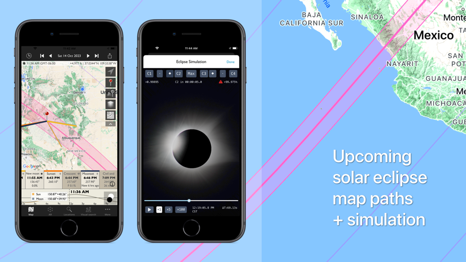
The Photographer's Ephemeris (TPE) helps plan outdoor photography shoots in natural light, particularly landscape and urban scenes. It's a map-centric Sun, Moon and Milky Way calculator: see how the light will fall on the land, day or night, for any location on earth.
Whether you need at-a-glance information on today's sun, moon and Milky Way data for your current location, or need to plan a precise alignment of the full moon for a future shoot, TPE has the tools you need. The combination of augmented reality, line-of-sight analysis and visual search supports the most sophisticated photo planning needs.
Night mode features a 3D representation of the Milky Way, pole stars and major constellations directly over the map, so you can easily visualize exactly how to align your shot.
Research and save your own list of favorite photographic locations, using 7 different map types (including 2 offline maps) and save them in your locations list. Favorite locations are always displayed right on the map.
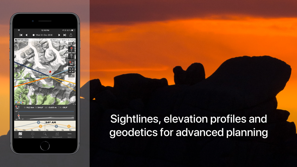
Advanced features including visual sun and moon search, automatic time zone and elevation detection, correction for atmospheric refraction and height above the horizon, ensuring that you have the best possible information for planning your shoot.
You can even determine when the sun or moon will rise from behind nearby hills and mountains.
Key features:
- Time/direction of sun, moon, and galactic center rise/set
- View azimuth and altitude of sun/moon and the galactic center for any time of day/night
- Milky Way, stars and asterisms visualization via 3D map overlay
- Moon phase and % illumination
- Civil, nautical and astronomical twilight
- 2 topographic maps
- 2 offline map types
- Movable map pins: drag and drop the pin exactly where you need it
- Map autorotation using the compass (on compatible devices)
- Shadow lengths displayed to scale on map
- Save any location you want: no fixed lists
- Celestial events including moon phases, apogee, perigee, solstice, equinox
- Solar eclipse details for August 12, 2026 and beyond: maps, simulator, times
- Network connection not required for rise/set time, azimuths and sun/moon position
Advanced features:
- Augmented reality view for on location scouting
- Saved location synchronization between devices and the free TPE web app
- Automatic time zone detection
- Elevation above sea level
- Distance, bearing and elevation angle between any two points
- Location import/export from KML
- Magnetic north option
- Configurable timeline display
- Sun/moon transit times
- 'Golden hour' time/duration
- Light pollution overlay
- Event countdown and notifications
Geek features:
- Line of sight analysis
- Find when the sun/moon will appear from behind a hill or ridge
- Advanced visual sun and moon search
- Azimuth or altitude search priority
- New crescent moon visibility
- Distance to the visible horizon
Available map types include:
- Standard, Satellite/Hybrid, Terrain
- OpenCycleMap Topographic
- OpenStreetMap
Sunrise/sunset color forecasts are available (covering lower 48, southern Canada and Europe) with an optional subscription to the Skyfire service, available via in-app purchase.
Note:
- Maps and elevation-based calculations require a data connection, except for offline map tiles previously downloaded and stored on your device
- Topographic map data is available only between 60°N and 47°S
- Availability of map types is subject to change, due to 3rd party map service availability, terms or conditions
스크린샷


Ad
가격 내역
- 현재 가격: $9.99
- 최소: $5.99
- 최대: $9.99
가격 추적
AppAgg 점수
82,100
AppAgg 예상 점수:
The Photographer's Ephemeris
82,100
점수가 높을수록 보통 AppAgg에서 더 강한 신호를 의미합니다.
기준: 🔥 인기 · ⭐ 사용자 평점 · 🕒 최신성 · 🏷️ 딜 · 🏬 스토어 데이터 · 👥 커뮤니티 활동
최신 AppAgg 데이터를 바탕으로 매일 다시 계산됩니다.
단축 URL: 복사됨!
새로운 기능
- 버전: 4.15.2
- 마지막 업데이트:
- 4.15.2
- Fix: eclipse path rendering on Apple Maps and Google Maps
- Updated eclipse data for upcoming solar eclipses
- UI fixes on Help screen
- Remove "legacy" from "Open in TPE 3D" action
Please send your feedback and suggestions to support@photoephemeris.com - we'd love to hear from you.
If you're enjoying TPE, a review on the App Store is really helpful and lets us keep improving the app.
추가 정보
개발자
- Crookneck Consulting LLC
- 플랫폼: iOS 앱 (3)
- 목록: 6 + 4
- 포인트: 1 + 1,776 ¡
- 순위: 0
- 댓글: 0
- 할인: 0
- 동영상: 0
- RSS: 구독
목록 (5)
- The Photographer's Ephemeris


포인트 (1)
-

- 177 Taban Bovin
- +1
순위 (0)
0 ☹️
댓글 (0)
가장 먼저 댓글을 남겨주세요 🌟
«The Photographer's Ephemeris». 플랫폼: iOS. 카테고리: 사진 및 비디오. 개발자: «Crookneck Consulting LLC». 첫 번째 릴리스: . 마지막 업데이트: . 현재 가격: $9.99. 최저 기록 가격: $5.99 (). 최고 기록 가격: $9.99 (). 이 타이틀은 아직 AppAgg에서 평가나 리뷰를 받지 못했습니다. 목록: 공개: 5, 비공개: 2. 추적된 포인트: 확인됨: 1, 간접: 1,535. 매장: App Store. 매장 평가: 4.7. 투표: 1,535. 사용 가능한 언어: English, French, German, Spanish. AppAgg는 «The Photographer's Ephemeris»의 가격 기록, 평점 및 사용자 피드백을 추적합니다. 향후 할인 및 업데이트 받기: RSS에서 확인할 수 있습니다. AppAgg는 애플리케이션을 호스팅하거나 소프트웨어를 배포하지 않습니다. 모든 상표, 로고 및 스크린샷은 해당 소유자의 자산입니다.
- 🌟 공유하기
- App Store
유사 항목
-
- Photographer's Ephemeris 3D
- iOS 앱: 사진 및 비디오 게시자: Crookneck Consulting LLC
- $11.99
- 목록: 1 + 2 0 0
- 포인트: 0 + 241 (4.2) 39k 버전: 1.5.2 3D Light Visualization for Outdoor & Night Photographers See exactly how natural light will fall on the land day or night, anywhere on Earth. TPE 3D helps outdoor photographers plan ... ⥯
-
- Couple AI - Photographer
- iOS 앱: 사진 및 비디오 게시자: MXY Ventures Private Limited
- 무료
- 목록: 0 0 0
- 포인트: 1 + 204 (4.5) 47k 버전: 1.0.31 Elevate your pre-wedding experience to new heights with our revolutionary app, "Couple Capture: AI Photoshoot"! Say goodbye to traditional photoshoots and hello to a seamless, ... ⥯
-
- Lightroom: AI Photo Editor
- iOS 앱: 사진 및 비디오 게시자: Adobe Inc.
- 무료
- 목록: 4 + 1 0 0
- 포인트: 6 + 334,046 (4.8) 978k 버전: 11.3.1 Ever wish your photos could really show what makes a moment special? Adobe Lightroom is a free photo and video editor that helps you do just that. From your dog s goofy grin to that ... ⥯
-
- Peachy - AI Face & Body Editor
- iOS 앱: 사진 및 비디오 게시자: SHANTANU PTE. LTD.
- 무료
- 목록: 0 0 0
- 포인트: 2 + 166,856 (4.9) 650k 버전: 2.11.2 Aiming at perfection in everything, Peachy is a powerful & handy pro photo editor, especially for selfie editing, portrait retouching, and natural-looking body adjustments. Everybody ... ⥯
-
- Mojo: AI Video & Reels Editor
- iOS 앱: 사진 및 비디오 게시자: Archery Inc.
- 무료
- 목록: 2 0 0
- 포인트: 5 + 138,061 (4.9) 432k 버전: 1.265.0 Creating trending social content has never been simpler. Mojo is an app designed to help you make amazing video content for Instagram and TikTok and more. Mojo is made in Paris and has ⥯
-
- Dazz Cam - Vintage Camera
- iOS 앱: 사진 및 비디오 게시자: DAZZ PTE. LTD.
- 무료
- 목록: 10 5 (1) 0
- 포인트: 20 + 106,346 (4.8) 504k 버전: 2.17 Dazz Camera, Pro Photographer in your Pocket. We believe in keeping it simple, no need for post-editing. With just one tap, you can capture the most authentic vintage photos or videos, ⥯
-
- Lightleap by Lightricks
- iOS 앱: 사진 및 비디오 게시자: Lightricks Ltd.
- 무료
- 목록: 1 + 1 0 0
- 포인트: 0 + 98,655 (4.7) 456k 버전: 1.21 Finally, you can take the photo you actually meant to take! Lightleap (formerly Quickshot) is a photo editor that proves you no longer need to be a professional photographer to take ... ⥯
-
- Planit Pro: Photo Planner
- iOS 앱: 사진 및 비디오 게시자: JIDE Software, Inc.
- $4.99
- 목록: 1 0 0
- 포인트: 5 + 1,412 (4.8) 93k 버전: 10.7.21 Please email info@planitphoto.com for bug reports or feature requests. Please also remember to visit https://youtube.com/playlist?list=PLTmlTTxPbBbcn1Fd1NRWTOczTY1RYEug4 for more video ⥯
-
- PhotoApp - AI Photo Enhancer
- iOS 앱: 사진 및 비디오 게시자: SCALEUP YAZILIM HIZMETLERI
- 무료
- 목록: 0 0 0
- 포인트: 2 + 85,798 (4.6) 393k 버전: 2.8.7 Turn your old, blurry photos into high resolution using the most advanced AI photo enhancer with just one tap! PhotoApp uses state-of-the-art Artificial Intelligence to unblur, ... ⥯
-
- Halide Mark II - Pro Camera
- iOS 앱: 사진 및 비디오 게시자: Lux Optics Incorporated
- 무료
- 목록: 16 + 17 0 0
- 포인트: 36 + 12,895 (4.4) 161k 버전: 2.27.3 **Please note: Halide is *not free*. We do offer a 7-day free trial for annual memberships. Don't like subscriptions? You can also buy the app outright with a single in-app purchase.** ⥯
-
- AI Mirror: AI Photo Editor
- iOS 앱: 사진 및 비디오 게시자: POLYVERSE ENTERTAINMENT INC.
- 무료
- 목록: 0 + 1 0 0
- 포인트: 6 + 46,852 (4.7) 312k 버전: 7.0.1 AI Mirror the best AI photo editor and video creator. Transform your photos and videos with hundreds of AI filters, trending style effects, and powerful editing tools. NEW: AI Better ... ⥯
-
- Photo Editor
- iOS 앱: 사진 및 비디오 게시자: Maple Media Apps, LLC
- 무료
- 목록: 1 5 (1) 0
- 포인트: 6 + 43,073 (4.6) 313k 버전: 5.5.8 Photo Editor, is one of the most powerful design studios that fits in the palm of your hands. With over 50 million installs, Photo Editor is the premier all-in-one editor to fulfill ... ⥯
-
- Photomator – Photo Editor
- iOS 앱: 사진 및 비디오 게시자: Apple
- 무료
- 목록: 15 + 16 0 0
- 포인트: 31 + 3,579 (4.5) 176k 버전: 3.4.14 Photomator is the most powerful photo editing app ever designed for a mobile device. It includes an extensive collection of cutting-edge color adjustments, automatic selections powered ⥯
-
- MOLDIV Photo Editor, Collage
- iOS 앱: 사진 및 비디오 게시자: JellyBus Inc.
- 무료
- 목록: 4 + 2 0 0
- 포인트: 2 + 37,447 (4.7) 288k 버전: 7.3 MOLDIV™, Creative Story Maker From professional photo editing to easy and quick video making, enjoy MOLDIV and share your work on social media! MOLDIV offers hundreds of video ... ⥯
최근 본 항목
마지막 업데이트:
AppAgg에서 사용할 수 있는 검색 연산자