| ผู้พัฒนา: | Navtech Software (38) | ||
| ราคา: | * ฟรี | ||
| การจัดอันดับ: | 0 | ||
| ความเห็น: | 0 เขียนความเห็น | ||
| รายการ: | 0 + 0 | ||
| แต้มแล: | 0 + 0 ¡ | ||
| App Store | |||
คำอธิบาย
")
The nearest Devonport HW time to the actual time is selected from the database and the relevant streams chart is displayed, together with the time period for which the chart is valid.
As the time moves to the next valid period, the relevant hourly chart is auto displayed.
* Swiping on the chart (or using navigation buttons), displays the next or previous tidal hour chart.
* Whenever the chart displayed is valid at the current time, the validity period is displayed in green.
* Pinching the screen zooms the chart
* Tapping the location button shows your actual boat position on the chart.
* Select Local or UTC time.
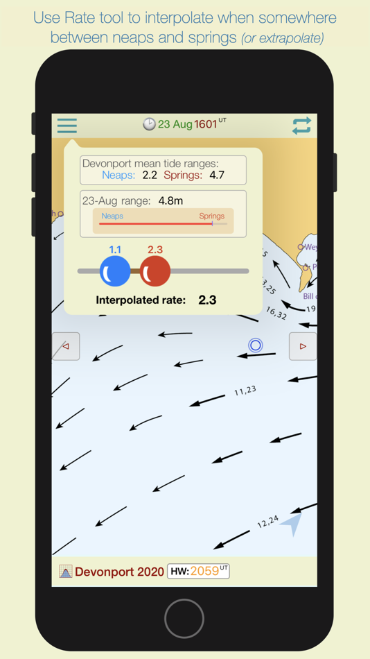
Select the rate tool to auto calculate the interpolated tidal rate when in between neaps and springs.
Select the 'Set' tool to measure the precise true course of any tidal stream arrow. (in-app purchase)
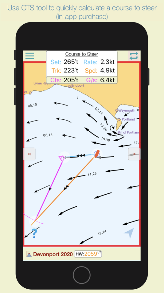
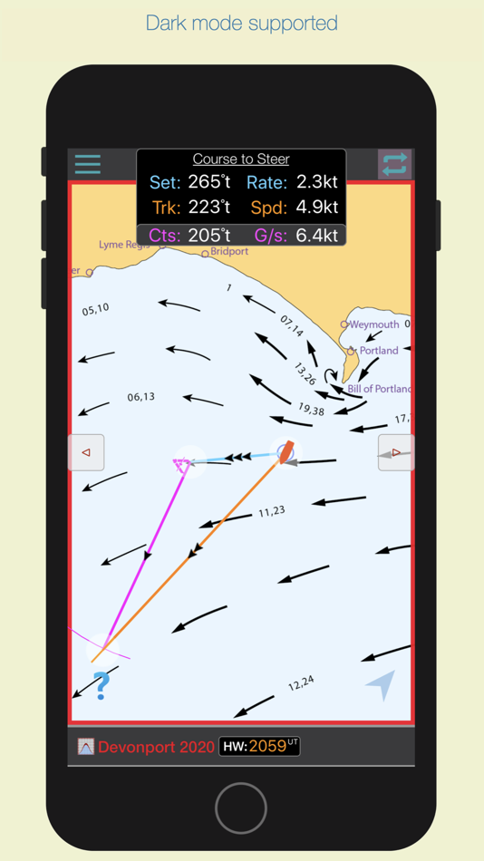
Select the 'CTS' tool to calculate a Course to Steer. (in-app purchase)
The app automatically selects the nearest Devonport HW time of the day, but if you want to see data for the next or previous HW of the day, swipe forward or back to advance the tidal hour.
For forward planning, tap on the date to select a different date, whereupon data relevant to that date will be displayed.
ภาพหน้าจอ


ราคา
-
* การซื้อภายในแอพ - วันนี้: ฟรี
- ต่ำสุด: ฟรี
- มากที่สุด: ฟรี
ติดตามราคา
ผู้พัฒนา
- Navtech Software
- แพลตฟอร์ม: Android แอป (16) iOS แอป (21) iOS เกม (1)
- รายการ: 0 + 0
- แต้มแล: 0 + 3 ¡
- การจัดอันดับ: 0
- ความเห็น: 0
- ลดราคา: 0
- วิดีโอ: 2
- RSS: ติดตาม
แต้มแล
0 ☹️
การจัดอันดับ
0 ☹️
รายการ
0 ☹️
ความเห็น
แสดงรีวิวเป็นคนแรกเลย 🌟
ข้อมูลเพิ่มเติม
รายชื่อติดต่อ
- เว็บไซท์:
 http://www.navsoft.co.uk
- 🌟 แชร์
- App Store
คุณอาจชอบ
-
- Bay Ridge Trails
- iOS แอป: การนำทาง โดย: Bay Ridge Civic Association
- ฟรี
- รายการ: 0 + 0 การจัดอันดับ: 0 ความเห็น: 0
- แต้มแล: 0 + 5 (3.6) เวอร์ชัน: 1.1.1 The Bay Ridge Trails App is a hiking trail app that uses GPS to map out Bay Ridge trails. Users can use the app to find the trails and navigate around Bay Ridge. The app provides a ... ⥯
-
- Transit - for BART SF Bay Area
- iOS แอป: การนำทาง โดย: Kent Wang
- ฟรี
- รายการ: 0 + 0 การจัดอันดับ: 0 ความเห็น: 0
- แต้มแล: 0 + 0 เวอร์ชัน: 1.0 Transit is a live schedule and estimates app for BART San Francisco Bay Area Rapid Transport. Support for all iPhones iOS 13.0 and up. ⥯
-
- Handy Compass: Digital Compass
- iOS แอป: การนำทาง โดย: APPS BAY LIMITED
- ฟรี
- รายการ: 0 + 0 การจัดอันดับ: 0 ความเห็น: 0
- แต้มแล: 0 + 1 (5.0) เวอร์ชัน: 1.0.2 Handy Compass is a compass app that helps you find directions or locate items whenever needed. You can also use this app to find your car in the parking lot. FEATURES: - Add and track ... ⥯
-
- MyHailer
- iOS แอป: การนำทาง โดย: Foggy Bay Technologies
- $14.99
- รายการ: 0 + 0 การจัดอันดับ: 0 ความเห็น: 0
- แต้มแล: 0 + 0 เวอร์ชัน: 1.2 The functions and features of a marine hailer for less cost. A key safety feature is automatically repeating fog horn sequences allowing you to focus on navigation in restricted ... ⥯
-
- Citymapper: All Live Transit
- iOS แอป: การนำทาง โดย: Citymapper Limited
- ฟรี
- รายการ: 0 + 3 การจัดอันดับ: 0 ความเห็น: 0
- แต้มแล: 1 + 96,409 (4.9) เวอร์ชัน: 11.36.3 Instantly compare your travel options in real-time across all transport modes globally! Easily navigate your city with turn-by-turn directions for all your public transportation, ... ⥯
-
- iStreams North Sea (E)
- iOS แอป: การนำทาง โดย: Navtech Software
- * ฟรี
- รายการ: 0 + 0 การจัดอันดับ: 0 ความเห็น: 0
- แต้มแล: 0 + 0 เวอร์ชัน: 2.93 iStreams displays the valid hourly North Sea tidal stream atlas for the current real time, in reference to the time of high water at Dover... a smart app, fully functional offline. ... ⥯
-
- i-Boating: Marine Charts & Gps
- iOS แอป: การนำทาง โดย: Bist LLC
- ฟรี
- รายการ: 0 + 1 การจัดอันดับ: 0 ความเห็น: 0
- แต้มแล: 1 + 13,699 (4.5) เวอร์ชัน: 163.0.0 This App offers access to Marine Charts for USA,Canada,UK/Ireland,Germany,Netherlands/Holland & Europe Rivers (Danube,Drava,Rhein etc). Coverage includes NOAA marine vector ... ⥯
-
- Nexar Classic
- iOS แอป: การนำทาง โดย: Nexar Inc.
- ฟรี
- รายการ: 0 + 0 การจัดอันดับ: 0 ความเห็น: 0
- แต้มแล: 0 + 11,426 (4.4) เวอร์ชัน: 6.16.1 Compatible dash cams: Nexar Classic is the operational app of Nexar's WiFi dash cams: Nexar Beam, Nexar Pro, and other compatible models. For nexarOne and beam2 LTE dash cams, look for ⥯
-
- BaseMap: Hunting GPS Maps
- iOS แอป: การนำทาง โดย: BaseMap Inc
- ฟรี
- รายการ: 0 + 0 การจัดอันดับ: 0 ความเห็น: 0
- แต้มแล: 0 + 8,999 (4.6) เวอร์ชัน: 6.1.7 Guaranteed land ownership maps, mobile hunt planner with draw odds, industry leading GPS tools for hunters and outdoorsmen. OFFLINE GPS and TRACKING Cache maps for offline use without ... ⥯
-
- Stampede by the Sea 2025
- iOS แอป: การนำทาง โดย: Wild In Art Ltd.
- $1.99
- รายการ: 0 + 0 การจัดอันดับ: 0 ความเห็น: 0
- แต้มแล: 0 + 0 เวอร์ชัน: 1.0.3 Create your Wild in Art account to find sculptures across Bridport, West Bay, and Lyme Regis while unlocking exciting rewards and milestones along the way. Discover the design ... ⥯
-
- TroutRoutes: Fly Fishing App
- iOS แอป: การนำทาง โดย: onXmaps, Inc.
- ฟรี
- รายการ: 0 + 0 การจัดอันดับ: 0 ความเห็น: 0
- แต้มแล: 3 + 3,702 (4.5) เวอร์ชัน: 5.3.2 TroutRoutes by onX is the #1 GPS mapping tool for trout streams and fly fishing. As the first mapping tool that includes interactive GPS fishing maps for every trout stream in the ... ⥯
-
- Singapore MRT Map Route 新加坡地铁
- iOS แอป: การนำทาง โดย: Wan Peng
- ฟรี
- รายการ: 0 + 0 การจัดอันดับ: 0 ความเห็น: 0
- แต้มแล: 0 + 122 (4.6) เวอร์ชัน: 2.9.6 Singapore MRT Map Route is designed to allows user to get the best route within a second. - View the lastest subway map - Caculate the best route between two stations - Display ... ⥯
-
- ParkEasy: Reserve Parking
- iOS แอป: การนำทาง โดย: PixelByte Sdn Bhd
- ฟรี
- รายการ: 0 + 0 การจัดอันดับ: 0 ความเห็น: 0
- แต้มแล: 0 + 1 (5.0) เวอร์ชัน: 3.7.3 NEW LOCATIONS ParkEasy is now available at iOi City Mall, Ativo Plaza, 1 Mont Kiara, Lot 10, 163 Retail Park, Sunway Pyramid, Sunway Velocity and so on. Check it out! CHARGING STATION ... ⥯
-
- Bristol Maps
- iOS แอป: การนำทาง โดย: Chris Hager
- * ฟรี
- รายการ: 0 + 0 การจัดอันดับ: 0 ความเห็น: 0
- แต้มแล: 1 + 14 (4.0) เวอร์ชัน: 3.13.1 Bristol Maps is designed specifically for commercial fishermen to navigate using the latest satellite imagery. Currently serving Bristol Bay and Copper River watersheds. Say goodbye to ⥯