| Programista: | JOMO Solutions Ltd (17) | ||
| Cena: | $1.99 | ||
| Rankingi: | 0 | ||
| Opinie: | 0 Napisać recenzję | ||
| Listy: | 0 + 0 | ||
| Punkty: | 0 + 0 ¡ | ||
| App Store | |||
Opis
")
Beautifully detailed maps supplied by Ordnance Survey.
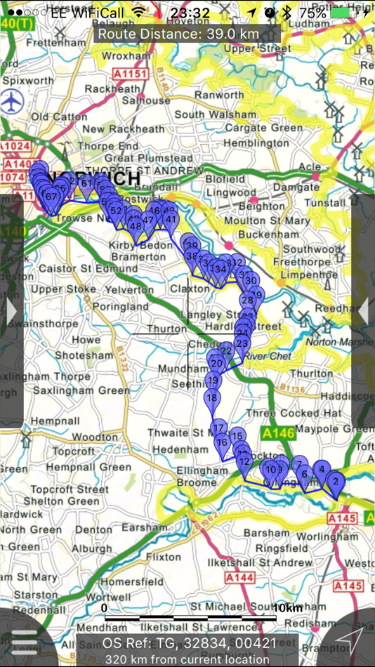
The Broads Maps provides a useful offline (no mobile signal required) mapping reference and navigation aid whilst travelling throughout the Norfolk and Suffolk Broads by footpath, road, rail, canal, lake and river. Intuitive route and waypoint management features are implemented enabling creation, modification, deletion, import and export of routes. A powerful offline search facility can locate places, roads, post codes and hills within the region. Worldwide online Apple Maps (Standard, Satellite and Hybrid) with map features that users are used to are available on both offline and online maps as well as providing 3D buildings on Apple maps (where available).
Maps
7 different levels of offline 2014/5 Ordnance Survey map detail from national overview to street view within the region. (No data connection required)
Progressively more detailed maps are automatically loaded as the map view is zoomed. The OS recommended viewing scales for the more detailed maps are approximately as follows:
1:1000,000 (Whole GB)
1:250,000
1:50,000
1:25,000
1:10,000 (Roads/streets labelled)
The map region of the more detailed maps covers a rectangular region around the national park boundary (ref. http://jomosolutions.com/Maps)
- Contours with height information and annotated height points
- Extensive footpaths from ©OpenStreetMap contributors
- National Park boundary demarkation
App
- Route/Waypoint management
- Offline search functionality with searchable locations (places, roads, post codes and hills). (For the place search a location's latitude and longitude is accurate to 0.1 of a minute of the centre point of the 1x1 km National Grid square in which the name falls)
- Detailed hill information, including height, OS Grid Ref, latitude and longitude, region, parent, classification, drop and hill specific links to Streetmap, Geograph and Hill Bagging web sites
- Display of current GPS position as OS Grid Reference or WGS84 latitude and longitude
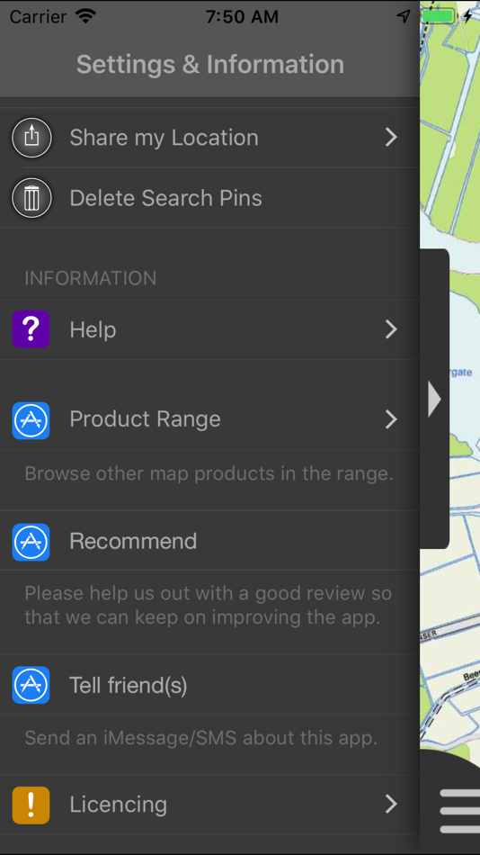
- "Share My Location" allowing users to share an image of their current location and location references. Buttons are provided to share location information by Facebook, Twitter, iMessage/SMS and e-mail
- Online access to worldwide Apple Standard, Satellite and Hybrid maps
- Apple 3D Buildings are displayed on Apple Standard maps
- Apple maps contain Points of Interest
- User location can be tracked with or without heading on all online and offline maps (GPS capable devices only)
- Display of scale bar in either metric or imperial units
- Display of current speed
- Zoom, pan, rotation of all maps
- Pitch of Apple Standard and Ordnance Survey maps
- Selection of current location annotation for display of speed and location data
- User setting for speed display in Miles per Hour (mph) or Kilometres per Hour (kph)
- Selection of search result pin annotations to display location information
- Collective deletion of search result annotation pins
- A user guide is provided within
Further application details.
The OS search data was published by Ordnance Survey in 2014.
Extracts from "The Database of British and Irish Hills" v14 published 22/04/2014 (ref. http://www.hills-database.co.uk/index.html )
No warranty
The data is supplied by Apple, Ordnance Survey, contributors to OpenStreetMap and Database of British and Irish Hills.
The Information is licensed 'as is' and the Information Provider and/or Licensor excludes all representations, warranties, obligations and liabilities in relation to the Information to the maximum extent permitted by law.
The Information Provider and/or Licensor are not liable for any errors or omissions in the Information and shall not be liable for any loss, injury or damage of any kind caused by its use.
This app is not a substitute for a paper map and compass.
Zrzuty ekranu


Nowości
- Wersja: 2.1.1
- Zaktualizowano:
- Fixed intermittent failures within the search functionality.
If you like the app please leave an app review.
Cena
- Dziś: $1.99
- Minimalna: $1.99
- Maksymalna: $1.99
Monitoruj ceny
Programista
- JOMO Solutions Ltd
- Platformy: iOS Aplikacje (17)
- Listy: 1 + 1
- Punkty: 0 + 16 ¡
- Rankingi: 0
- Opinie: 0
- Zniżki: 0
- Filmy: 0
- RSS: Subskrybuj
Punkty
0 ☹️
Rankingi
0 ☹️
Listy
0 ☹️
Opinie
Bądź pierwszą osobą, która napisze recenzję 🌟
Dodatkowe informacje
- Wersja: 2.1.1
- ID: com.jomosolutions.The-Broads-Maps
- Kategoria:
iOS Aplikacje›Nawigacja - System operacyjny:
Apple Watch,iPad,iPhone,iOS 8.0 i nowsze - Rozmiar:
243 Mb - Obsługiwany język:
English - Ocena treści:
4+ - App Store Ocena:
0 - Zaktualizowano:
- Data wydania:
Kontakty
- Witryna internetowa:
 http://jomosolutions.com/Maps/
Może ci się spodobać również
-
- Organic Maps・Offline Map
- iOS Aplikacje: Nawigacja Przez: Organic Maps
- Bezpłatny
- Listy: 1 + 1 Rankingi: 0 Opinie: 0
- Punkty: 3 + 644 (4.7) Wersja: 2025.10.05 Detailed offline maps with places that don't exist on other maps Cycling routes, hiking trails, and walking paths Contour lines, elevation profiles, peaks, and slopes Turn-by-turn ... ⥯
-
- Avenza Maps: Offline Mapping
- iOS Aplikacje: Nawigacja Przez: Avenza Systems Inc.
- Bezpłatny
- Listy: 0 + 1 Rankingi: 0 Opinie: 0
- Punkty: 0 + 122,085 (4.8) Wersja: 5.4.3 Avenza Maps, #1 app for hiking, biking and all trails. Featuring maps from National Geographic, national parks and more! On your next adventure, stay on track with GPS using offline ... ⥯
-
- Offline GPS Converter
- iOS Aplikacje: Nawigacja Przez: Artur Pahasian
- Bezpłatny
- Listy: 0 + 0 Rankingi: 0 Opinie: 0
- Punkty: 0 + 1 (3.0) Wersja: 1.0 Offline GPS Converter helps you instantly convert geographic coordinates no internet needed. Whether you're a field worker, radio operator, or outdoor enthusiast, this app delivers ... ⥯
-
- maps.earth
- iOS Aplikacje: Nawigacja Przez: Michael Kirk
- Bezpłatny
- Listy: 0 + 0 Rankingi: 0 Opinie: 0
- Punkty: 0 + 3 (3.0) Wersja: 1.13 Explore the world and get low stress directions powered by OpenStreetMap. maps.earth is built on open source. We never show you ads or sell your data. We just want a nice map. ⥯
-
- Maps My Location
- iOS Aplikacje: Nawigacja Przez: Rohit Bhayani
- Bezpłatny
- Listy: 0 + 0 Rankingi: 0 Opinie: 0
- Punkty: 0 + 1 (1.0) Wersja: 1.0 A Map My Location app for iOS is a software application designed to assist You in navigating from one location to another using the Global Positioning System (GPS) technology. Key ... ⥯
-
- Offline Maps: GPS Tracker GPX
- iOS Aplikacje: Nawigacja Przez: SERGEI BEZDENEZHNYKH
- $7.99
- Listy: 2 + 1 Rankingi: 0 Opinie: 0
- Punkty: 23 + 44 (4.7) Wersja: 3.3.8 Create, import, export tracks with waypoints. Supports offline maps, no time limits, no ads, no in-app purchases. The main functions of the application: - loading and unlimited storage ⥯
-
- Maps 3D PRO - Hike & Bike
- iOS Aplikacje: Nawigacja Przez: movingworld GmbH
- $3.99
- Listy: 1 + 4 Rankingi: 0 Opinie: 0
- Punkty: 0 + 202 (4.4) Wersja: 6.8 Enjoy exploring the great outdoors? If you re a fan of biking, hiking and running then Maps 3D is the ideal app designed for planning your outdoor adventures. Whereas other mapping ... ⥯
-
- Maps Anywhere: Offline GPS
- iOS Aplikacje: Nawigacja Przez: Ali Mert TUFEKCI
- Bezpłatny
- Listy: 0 + 0 Rankingi: 0 Opinie: 0
- Punkty: 5 + 2 (5.0) Wersja: 1.0.0.8 SecureTrek Maps Anywhere - Stay Oriented in the Wild Every year, thousands of people get lost while trekking or exploring the outdoors due to poor visibility, disorientation, or losing ⥯
-
- Offline Map Navigation
- iOS Aplikacje: Nawigacja Przez: VirtualMaze
- Bezpłatny
- Listy: 0 + 0 Rankingi: 0 Opinie: 0
- Punkty: 0 + 304 (4.3) Wersja: 6.1.8 Search, Get Directions & Navigate anywhere even without internet connection Turn-by-turn route instructions & real-time navigation Find directions for car, motorbike, bicycle or walk ... ⥯
-
- Offline Maps Nav by Karta GPS
- iOS Aplikacje: Nawigacja Przez: Karta
- * Bezpłatny
- Listy: 0 + 0 Rankingi: 0 Opinie: 0
- Punkty: 0 + 4 (3.3) Wersja: 2.51.03 Navigate in Germany and download any map from all over the world! This special German version offers free traffic and Speed Radars information with lifetime updates. All maps are free ... ⥯
-
- Goat Maps
- iOS Aplikacje: Nawigacja Przez: Goat Maps, inc.
- * Bezpłatny
- Listy: 0 + 0 Rankingi: 0 Opinie: 0
- Punkty: 0 + 46 (4.7) Wersja: 2025.11 Goat Maps is the next-generation navigation app designed for outdoor adventures. Built from the ground up in 2024, Goat Maps offers unmatched reliability and ease of use, perfect for ... ⥯
-
- Blue Light Maps
- iOS Aplikacje: Nawigacja Przez: Blue Light Maps
- * Bezpłatny
- Listy: 0 + 0 Rankingi: 0 Opinie: 0
- Punkty: 0 + 0 Wersja: 2025.09.24 Navigate smarter and arrive faster with BlueLight Maps the navigation app built for the frontline, by the frontline. Specifically designed for police, EMTs, firefighters and private ... ⥯
-
- Maps And Navigation
- iOS Aplikacje: Nawigacja Przez: Varsha Patel
- * Bezpłatny
- Listy: 0 + 0 Rankingi: 0 Opinie: 0
- Punkty: 0 + 0 Wersja: 6.0 MapsAndNavigation App is a powerful and user-friendly tool designed to assist individuals in navigating their way through various locations with precision and ease. Best road trip ... ⥯
-
- Goose Maps for Watch
- iOS Aplikacje: Nawigacja Przez: GOOSE MAPS LTD
- Bezpłatny
- Listy: 0 + 0 Rankingi: 0 Opinie: 0
- Punkty: 0 + 293 (4.1) Wersja: 1.3.2 Features - Navigate easily everywhere Our pedestrian and bike navigation perfectly work even if your iPhone stayed at home. - Search objects you need Our search helps you to find ... ⥯